A new navigational beacon was installed at Grief Point Nov. 29, 2023 by the Marine Civil Infrastructure unit of the Canadian Coast Guard, 87 years after the first one was installed in 1936. There is, they tell me, no record of what precipitated its establishment, of what particular grief signaled the need for a light.
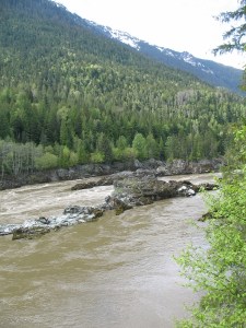
There is much speculation about why this rather innocuous point is so named. It’s a low shelf reaching out into Malaspina Strait, whose only danger to navigation is that an unwary boat might be pushed onto the shifting gravel that makes up its beach. Anyone shipwrecked could just walk a few feet up onto solid ground.
The BC Geographical Place Names database says the name was officially adopted in 1945 “based on British Admiralty Chart 580, 1862 et seq. Origin/significance not known.” The database also refers to historian Athelstan Harvey, who speculated that its name came because “it is an exposed spot in a westerly wind, causing grief to many a mariner.”
That may well be the case. Further correspondence with BC Geographical Place Names says, “The version of British Admiralty Chart 580 we have in our office is from 1860, with corrections in 1864, and has Grief Point labelled, so I think it’s safe to say the name existed by 1864.”
The men behind the early coastal mapping expeditions are named on the charts themselves and their work led to the establishment of the first beacons on the coast in the 1860s. Captain G. H. Richards, conducted the Vancouver Island Survey between1860 – 1862. Another name on the 1860’s chart was Pender.
In Boats, Bucksaws and Blisters by Bill Thompson (1990), Golden Stanley (GS) interviewed Roy Padgett (RP) in 1982 about Grief Point’s name:
“RP: When they were logging from Fiddlers, that road came straight down and the log dump was right where Gus Courte used to live … Well, apparently, when they dumped the logs in there, every so often they’d get caught with a westerly, and they’d get around the point [the logs would]and they got in the habit of saying there’s nothing but grief here,” and that’s the story I heard.
“GS: Well, it goes back further than that because … I think it was Pender who came up on the Trumpet to survey the coast at that time … and his log is lost, but the name goes back into the eighties [1880s] and from there on it’s called Grief Point. Before that, there’s no name on it. It was during his survey that the name became Grief Point. His log, apparently, went over to England and became lost. There’s no record of it …”
qathet Museum and Archives’ website also has notes on the naming.
“There is some speculation as to where the name Grief Point comes from. One possibility was that it refers to an epidemic within the indigenous population, another is of a wreck in which three men perished, while another is that it refers to the tugs and boats that would shelter behind the point during storms, to get away from the ‘grief’.”
Mom’s late friend, Fran Gregory, who used to live just above the point, painted five or six tugs lined up there with their boom stretched out behind them.
The museum site goes on to say, “At one point the area was also referred to as ‘Pneumonia Flats’ and referred to the flat area by the lighthouse in Grief Point. This area was a farm from the 1880’s and was sold in the middle 1960’s for a sub-division.”
Oddly enough, the references to the Tla’amin peoples’ use of the area talk about the protection it provided. Sliammon Life, Sliammon Land by Dorothy Kennedy & Randy Bouchard, states:
“The Sliammon name for Grief Point is Xákwuem, “having cow parsnip” referring to the abundance of “Indian rhubarb” (cow parsnip) that used to grow here. This was an important camping site because it afforded good protection from the southeast wind. In more recent years, before the area was developed, the Indian people planted gardens here.”
I’ve never understood the reference to protection. When my grandfather, who had lived many years in Shetland before bringing his family first to Hernando Island and then to Powell River, a man who undoubtedly knew something about wind, found out my mom and dad were planning to build a house in the new subdivision down at Grief Point, he exclaimed. “Surely you’re not going to build in yon windy hole!”
And windy it is. In rough weather we’ve seen tugs trying to round the point, sometimes looking as if they’re not moving at all. Other times, they actually start to slip back and end up executing a rather perilous looking turn to head into the shelter below Penticton Avenue.
The new lighthouse is the third one we’ve seen since my family moved down to the new subdivision in 1968. I think, from the photos, there was at least one between the first in 1936, and the one removed to make way for the 1968 version. TJ Courte, whose family lived at the point for many years, said her mom always said the beacon belonged to the queen, and they weren’t to climb on it!
I’ve tracked down a couple of old photos and of course, there was one when we built down here. My dad wrote several letters trying to get the lighthouse plot tidied up so it fit more neatly into the new subdivision, which they finally did. And they took up his offer to mow the lawn around the beacon in exchange for the use of the electrical outlet in the body of the tower, an outlet connected to the BC Hydro grid.
The first (I think) beacon.The beacon in the distance in the market garden days.The second beacon behind the 1968 version.
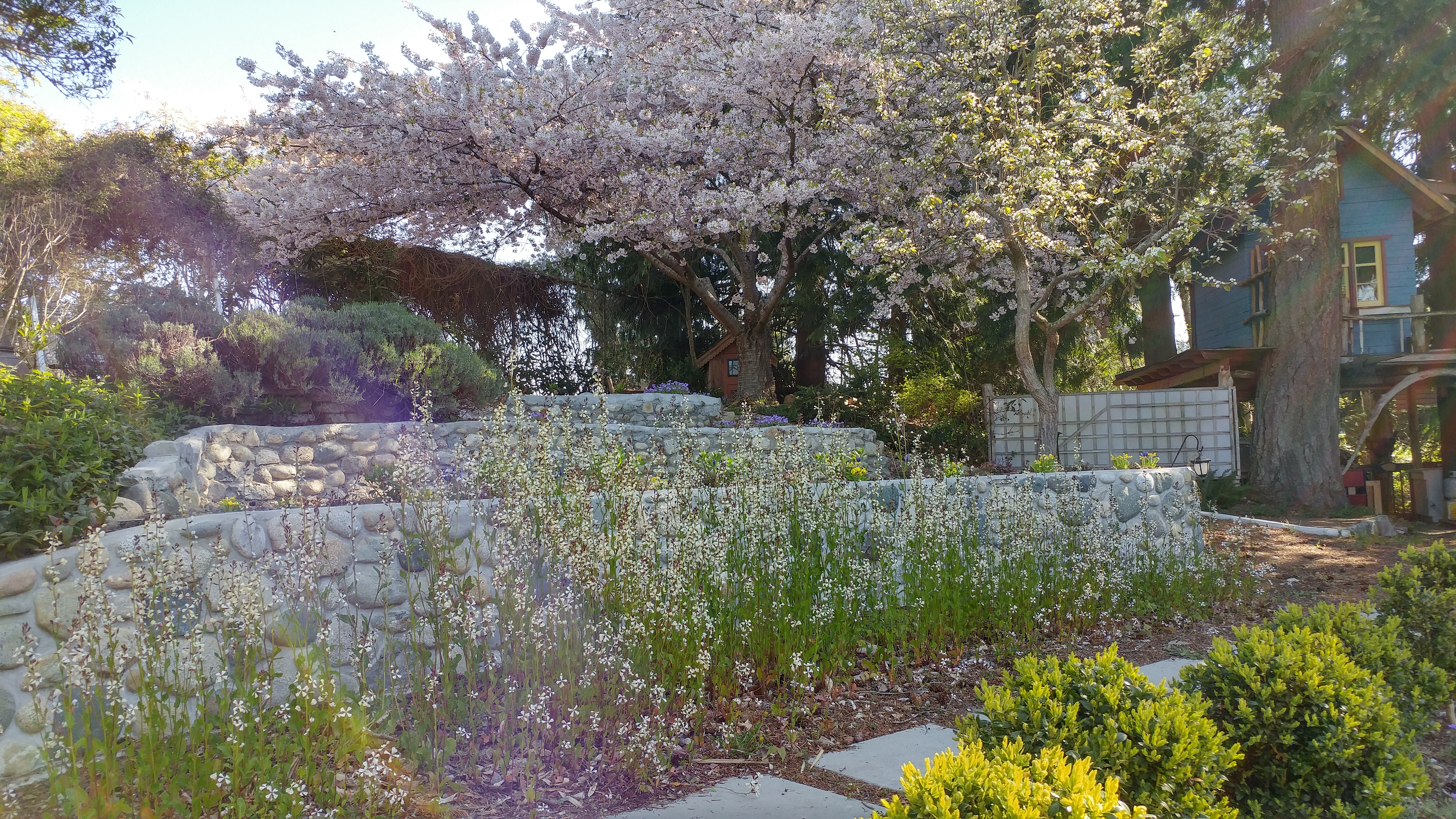
The new tower is nowhere near as dramatic a landmark as the old red and white rocket ship blinking its white light out into the strait (as well as into many of the houses in the neighbourhood). The new light flashes red and is much less intrusive. Its blocky silhouette with the solar panels and battery look a bit like a cheerful robot holding its hands out in greeting to the passing boats. We’ve decided to name it Brent after a dearly loved red-headed friend who died suddenly just a month before it was installed. A sturdy, stalwart beacon of light. Shine on, Brent.
The past few months have been difficult. We’ve lost close friends, all of them much too soon. And during those months, we were also slowly losing my mother. At 99, it wasn’t unexpected. She didn’t have dementia exactly, but she was getting confused and seemed to be spending more and more time deep inside herself. It is, I’ve been told, a characteristic of people who will soon leave.
And leave us she did. One Monday morning in September, she woke up as usual, ate breakfast, walked to the park just down the road, and continued her typical day. When she woke up the next morning, she didn’t want breakfast. Then she didn’t want lunch or her usual rye and water. Or dinner. And that was that. Ten days later, September 23, resting in her bedroom of over 50 years with my sister nearby, she quietly stopped breathing.
As we sort through the markers of her long life – letters, photographs, jewellery, clothes, books – I keep thinking about her. About our lives together and apart. About the last four and half years when we shared a home. Remembering, wondering, and mourning. Feelings I want to write about and will, but first I want to give you a sense of her by sharing the eulogy my husband, Lynn Shervill, wrote for her funeral.
Born on the Shetland Islands north of Scotland in 1924, Elizabeth Malcomson Berger (nee Anderson), or the blonde Viking as her second husband called her, emigrated to Canada with her parents in 1929. The family was sponsored by former North Island MLA Mike Manson and spent their first months in a tent on Hernando Island before moving to Westview. That was 95 years ago, back in the days of the Union steamships. Today, Betty is gone, just shy of her 100th birthday. But her family continues to receive reminders of the impact she had as a teacher on students in her beloved community.
For instance, when Stubberfield funeral home director Patrick Gisle was notified of Betty’s death, his immediate response was ”She was my Grade 1 teacher.” Another time, as Betty and I were leaving the hospital, an ambulance attendant walked up to her and said “JC Hill was the best school I ever went to and it was because of you.” When one of Betty’s care aides arrived at the house a few weeks ago she told us Betty had been her principal at JC Hill. One of her former students, Mike Slade, along with his wife Ulie, was a regular dinner companion. Such was Betty’s career she sometimes taught three generations of students from the same family.
Hundreds, probably thousands, of Powell River young people benefited from Betty’s 40-plus years as a teacher mostly at JP Dallos and JC Hill schools here in Powell River. This would not be surprising but for the fact she had always expected to settle into the traditional role of housewife for her first husband, Saskatchewan farm-boy Herb Peters, and their three children, Susan, Herb Jr. and Sheila. But it was not to be. Herb Sr, fell victim to polio in 1953 and, while he was able to live at home, he was unable to return to work and needed lots of physical assistance. Betty went back to teaching in order to support the family and somehow managed to earn a Bachelor of Education degree through summer school sessions at UBC and be promoted to principal at JC Hill.
Her family were an ever-present support to her and Herb over these years, arranging for the completion of the house Herb had been building on Quebec Street when he got sick, helping sell their little house on Butedale, taking care of the kids when Betty went back to work. Her mother, Kate, kept house for the family on and off over those years and even welcomed the whole bunch of them back into her home when they sold their Quebec Street house in order to build the beautiful waterfront home at Grief Point, a place Betty adored in spite of her father’s warning about building “in yon windy hole.”
Only two years later, Herb’s ability to breathe was severely compromised by post-polio syndrome and he died in his sleep just hours before they were to leave for Vancouver to seek medical advice.
While missing him greatly (she had two teenagers still living at home!), she kept her sense of adventure. Her mother, Kate, was a passionate fan of Robert Service. In 1969 Kate, Betty, 17-year-old Herb and 16-year-old Sheila set out in their 1968 Acadian for Dawson City, 3200 km away, half of it on gravel roads, with communities about 200 miles apart. After a stop in Barkerville to stoke the goldrush fever, they continued north. Herb Sr. must have been watching over them because, although they carried no more than a few snacks assuming they could stop at restaurants along the way, they never went hungry and always found a hotel room. The car did well and Sheila remembers only one flat tire along the way, though they met many people along the Alaska Highway, waiting days for car parts.
Betty survived a couple of years as a single mom of two teenagers still at home before they left for university. A year or two later, a local mill worker and avid reader by the name of Albert Berger came into her life. She wasn’t interested at first, but he was persistent and finally, instead of closing the door on him as he stood in the howling wind on her porch, she invited him in. Albert brought his two adult children, Alison and Lawrence, into the family along with a lot of humour and adventure. They had thirty wonderful years together. He and Betty played bridge, danced at the Beach Gardens, and were members of the Myrtle Point Golf Club. But their favourite activity was frequenting casinos in Las Vegas and Reno. Betty especially liked watching the musical headliners in Vegas and Albert, with his betting systems, was a star at the Craps table. He was such a good gambler that Betty didn’t have to get any cash from her bank for a year after Albert died, she kept finding money in pockets, envelopes, drawers and cupboards as she sorted through his belongings.
Another of Betty’s passions was swimming in the ocean, something she as a child in Shetland and did right up until last year when she went for a dip with Sheila. A couple of years earlier, she tried to talk Alison into joining her. Alison is not a fan of cold water and believes something scary is going to rise from the ocean deeps to get her. “Alison,” Betty said, “There’s nothing to worry about” and dove in, swimming right into a big jellyfish. She flew out of the water with stinging welts over her face and neck. As Alison tended to her, we know she was feeling at least a modicum of vindication.
One of Betty’s favourite pastimes was bridge. She played with both Herb Sr. and Albert and continued on even after Albert’s passing. She admitted she wasn’t a very good player but never, until about two years ago, missed a Friday afternoon game at the home of neighbour June Vogl. Her eyesight was failing and she had trouble hearing. As the months ticked by she was easily disoriented and had memory problems. But up until a month ago she would still sit at the breakfast table and help us with the New York Times crossword puzzle and Wordle, using our verbal clues to divine the correct answers.
Betty was the middle child of five. Her four siblings, two sisters and two brothers, all pre-deceased her but she was able to connect and say goodbye to her children, grandchildren and great grandchildren in the weeks before she died. She was loved by all and we will carry her in our hearts forever.
We’ve seen the harlequins and other ducks returning from their summer breeding grounds to the ocean in front of our house. When we lived in Smithers, we’d see them in the spring, the harlequins chugging up the turbulent melt waters of Driftwood Creek on their way to nest in the alpine meadows of the Babine Mountains.
Here in Powell River, the small creeks drain watersheds that begin and end within a short run to the ocean and don’t offer much that harlequins seem to need for breeding. But they do offer what many children need and love. Moving water to splash in, to fill their boots, to float their pea pod boats and dream of bigger voyages.
Squatter’s Creek, the creek of my childhood, did that for dozens of kids, especially because for a few short years it ran across the southeast corner of the J.P. Dallos school playground. My mother, Betty Anderson/Peters/Berger, taught there from about 1956 until she moved to J.C. Hill (now the Music Academy). She likes to tell of a six-year-old named Victor being very pleased with himself when he produced two or three little fish for her after a recess fishing expedition.
My sister Susan and several of her classmates remember when their Grade One teacher, Mrs. Winegarden, had them write the word Can’t on little pieces of paper and troop down the steep bank to the creek to send the word downstream; they were encouraged to never use the word again.
Susan’s friend, Judy Thompson, wrote, “I certainly do remember the creek behind J.P. Dallos and we did play there on weekends as well as sometimes ‘illegally’ at school! The kids were always getting into trouble for playing at the creek and it did flow quite fast at times … it used to flow right past my Auntie Connie and Uncle Bob Lyons’ property on Westview Road. We just took all that for granted … I remember the water was quite clear …”
In those days, both branches ran clear.
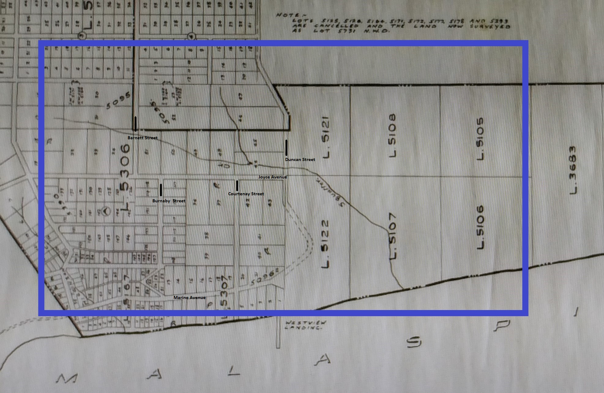
This 1931 map shows the two branches of Squatter’s Creek joining above Joyce Avenue just east of Courtenay Street before crossing Duncan, Joyce, Westview and Marine, entering the ocean where the sea walk begins today. Map courtesy of the Powell River Historical Museum and Archives 2013.63.5 Westview Light Power and Water Works District 01/10/1931
Stewart Alsgard remembers playing and swimming in it when he visited friends who lived beside it near Joyce and Courtenay. The Tom Pickles family moved onto seven acres of land above the creek just west of Duncan in the late 1940s. Tom Jr. hunted, fished and trapped in the bush around his home throughout his childhood. He remembers crossing one of the bridges (likely over Joyce) when he was coming home from visiting his friend Glen Husband down on Westview Avenue (see Boxwood Gardens below). After dark, he said, he’d run like crazy because there were deep shadows under that bridge and he imagined trolls living there. He also told of the time he and his friends decided to create a swimming hole on the creek above his house. They built a dam that included stakes, logs and sandbags. When he caught wind of it, Tom Sr. made them tear it apart – it was holding back quite a bit of water and could have flooded the houses down below if it broke.
By the time we moved to Quebec Avenue (1957) some of the creek had been piped under Duncan and Joyce; we had to go through Pickles’ property to get to it. My brother remembers walking there as a five or six-year-old, having been given a hatchet to protect his mother and a friend from bears. Later, I’d follow him to balance on logs and peer into their shadows in search of trout. Slow, silent movement was essential to not spook the fish.
The creek was supposedly named after “squatter” William Joyce, whose property it ran through. Joyce was, however, no squatter. According to his granddaughter Mary Carlson (nee Douglas), who came to live with him in 1931, Joyce was a pioneer of the Westview area. He had forty acres of land, which he had bought for $10 an acre. It was waterfront property; its width was defined by Duncan and Fairmont Streets.
My grandfather had 200 fruit trees, five or six hives of honey and a large garden on his property. He also kept chickens. A log house (situated on the spot where J.P. Dallos School stands today) was the main building; he later added on a complete house to provide extra space.
Squatter’s Creek ran through the property. WJ built a dam and a waterwheel on the creek; this fed through pipes to our house and others on Fourth (Duncan) and Fifth (Egmont) Streets. He charged 25 cents a month for those who wished to have piped water.
In the 1920’s and 30’s he laid out his 40 acre property into lots. He sold the water front lot for $250 for a location for the oil tanks [Andy Culos’s Esso tanks were just above the south harbour]. He sold other lots for $100.
Of course there was very little money around during the Depression years when the mill was working two weeks on and two weeks off, so he sold the lots at $5 down, and $5 a month until the $100 was paid off.
He gave approximately two acres of land for a school. The second Westview school was built on the school site, where the Municipal Hall is located today.
(From Rusty Nails & Ration Books: Great Depression & WWII Memories 1929-1945 by Barbara Ann Lambert; Trafford, 2002, pp 151 – 152.)
By 1950, instead of being a valuable resource, the creek was an impediment. When it came to building a new school, a central point in Westview was deemed the best area. A solution seemed apparent when a major portion of Joyce Farm was purchased by Powell River Municipality for parkland. The Powell River Co. Ltd. then generously provided a huge waterpipe to divert the creek which flowed through the farmland. The area was cleared, and fill was used to level the area. With completion of these renovations the remaining ideal school site was purchased by the Board, and construction [of J.P. Dallos, now École Côte-du-soleil] began. (From Powell River & District Schools: 1898-1983, collected by Alice Cluff p. 30.)
The remaining creek wasn’t fenced off and still tempted the kids to infractions through the 1950s.
Landfills
As far as I can tell, it was during the late fifties and early sixties that the creek became a convenient site for a series of landfills. I’m not sure in what order they happened. When I asked members of the Facebook page “You Know You Grew Up In Powell River” about their memories of Squatter’s Creek, Greg Coomber wrote, “they put the dump behind J.P. Dallos school and later behind Max Cameron School. Above the dump there are fish still to this day but below it is a yucky mess from all of the leaching. I used to fish in our back yard to get trout for dinner ’til they polluted it.”
Greg’s sister, Jody Coomber Turner wrote, “I remember trout when I was little, but also remember taking a jar of water from there to science class at Brooks years later. Mr. Ramsay’s class. Everyone had to bring a sample in so we could see what developed in the water. After a week, I was told I had to take mine away! It was full of long, skinny, segmented worms! That’s when there was long brown gunk flowing off the rocks in the stream! Yuck!”
Ed Dunn told about “falling in the creek behind J.P. Dallos when we use to play there. I remember when they were filling in the field with garbage, and we would grab the old 78 rpm records and use them as Frisbees.”
Bob Dice has more detailed memories:
At J.P. Dallos School in my Grade 1 (1958), the south west corner of the property was forested with trails – at recess the boys would run into the trails in a game of chase and tag – I once caught my friend, the very fast but small Bobby Rentmeister, who must have known Judo because in an instant he had me flipped over his back and on the ground. Other kids of my grade – Harvey Coomber, Wayne Rourke, Murray McNeil, John Straathof, Herb Peters. On the school’s south east corner – where the baseball field is now located – were dozens of mounds of dirt that were trucked in and dumped on otherwise level ground (maybe for the purpose of preload compacting the land which was possibly over top a garbage landfill for a future playing field?). The game the young boys played on the mounds was a very physical ‘defend the hill’ – several boys would race to be the first on top of the hill and the other boys tried to capture it. Lots of rolling and tumbling – a fabulous game that was ruined when the mounds were levelled a year or two later.
Clifford Lang wrote a letter to the editor Dec. 4, 2013 headlined, “Memories of Squatter’s Creek.”
I lived on Redonda Avenue in 1972, and always walked through to Duncan Street to Speed and Stan Toyota. I remember the smell of rotten garbage behind Adams Concrete and across Duncan where the old city bus garage was built. When Speed and Stan Toyota shop was there, there were holes drilled in the back through the concrete to let the methane gas escape. I was there getting my car fixed when that was happening.
I know Max Cameron Secondary School was built on a floating slab because of the landfill. The soccer field was always leaching methane and was wet and sloshy. It was never a good field. As a long-time resident of Powell River, I remember a lot about that area and played soccer on the Max Cameron field.
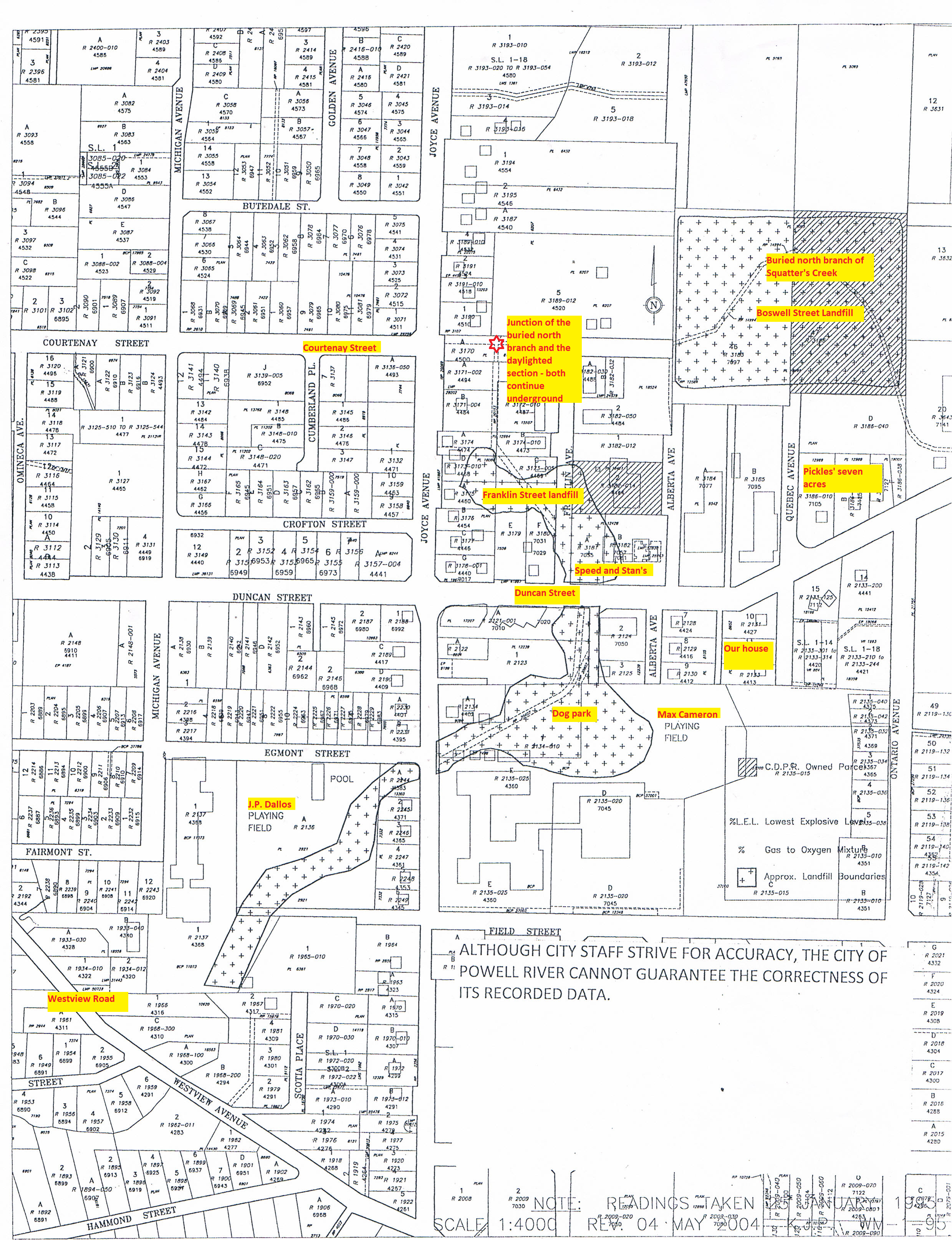
The 2004 map below shows those landfills as outlined blocks (filled in with +++). The buried sections of the creek are indicated by double lines through those blocks. The yellow blocks of type are my inserts. You can follow the north branch down through the Boswell Street block; the rest of the buried section continues through the Franklin block, across Duncan below the dog park, across Joyce and down past what used to be J.P. Dallos. I vaguely remember rummaging through the dump, but can’t remember exactly where it was. I don’t remember when they began filling in the north branch, turning it into the infamous Boswell Street dump. By 1966 we had moved to stay with my grandmother while my parents built our current home.
By 1967, complaints about rats, smoke, seagulls and smell from the Boswell dump were a major source of concern for the town, as the minutes below indicate:
January 3, 1967 Sanitary Land Fill. Mr. A. Graff, the spokesman for a large group of residents in the area of Boswell Street, expressed dissatisfaction on the present method of sanitary land fill. He pointed out that the residents in this area were suffering many hardships as a result of seagulls feeding on the garbage and depositing droppings on the houses, cars, clothes, etc. Dogs and cats were also congregating at the dump and feeding on raw garbage. Rats were also noticeably present in the surrounding area. After each member of the delegation was given sufficient time to ask questions, Reeve Pike expressed the opinion of Council. He pointed out that the Municipality had recently purchased property in the area of the previous sanitary land fill and, just as soon possible, the Municipality would enter onto the new property and the present dumping area would be abandoned. After the municipality have moved to the new area, the property owners in the area adjacent to Boswell Street will be consulted regarding damage that may have occurred during the time the land fill was located in the Boswell Street area.
The new area was, I think, not far downstream:
Reeve S. A. D. Pike stated that a property owner had volunteered the use of a gully on his property on Duncan Street for use as a sanitary land fill site. The Municipal Engineer was instructed to approach this gentleman and have this offer officially confirmed in writing.
Subsequently, the offer was accepted:
Letter from Mr. C. F. Cheshire regarding sanitary landfill on his property. Moved by Councillor J. Court seconded by Councillor R. J. Tucker that an agreement be drawn up between the Municipality and Mr. Cheshire regarding sanitary landfill on Mr. Cheshire’s property. Carried.
Cheshire’s property was near Franklin Street where it crosses Duncan. But I haven’t figured out exactly when the different sites were in use. Bob Dice remembers his friend Murray MacNeil, who owned a pellet gun: When we were ten to twelve (1964 est) he invited me on an interesting rat shooting party at the landfill at the end of Franklin Street. Murray scored a couple of kills.
The Squatter’s Creek landfills have come back to haunt the city. Gino Francescutti, an engineer with the municipality for many years, confirmed Clifford Lang’s story about Speed and Stan’s. They noticed when they dropped tires from the storage spot in the rafters, the floor bounced along with the tires. Drilling down, they found high levels of methane; the fire department was brought in to seal it off. It had to close down because of dangerous landfill gas emissions getting into the building through cracks in the cement. But when people were ready to sue the town, Francescutti went down to the old archives in the basement of Dwight Hall and found a report from Mac Campbell, Powell River’s first municipal engineer. The method he proposed (clear the bank of the chosen ravine; dump in the garbage, burn it, repeat) was state of the art garbage disposal for the times. When Campbell submitted the plan to his professional organization, he received accolades. So lawsuits were off the table.
But those plans have left several sections of city land unusable without major reclamation costs and continue to cause difficulties.
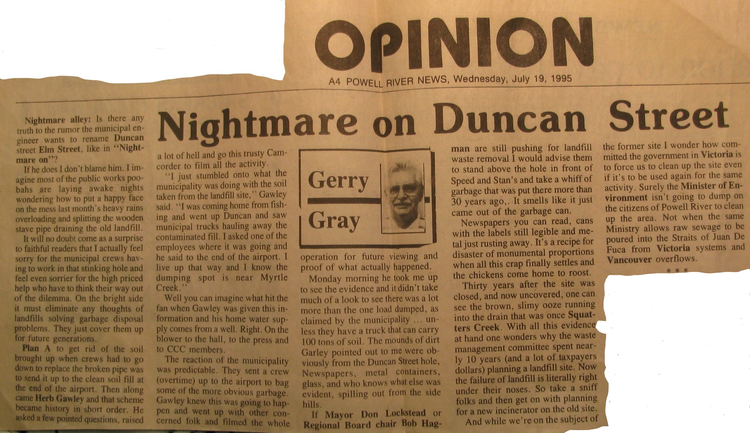
Bob Dice kindly shared much of his father’s archives about the creek. It included this 1995 article from the Powell River News.
It still goes on. This from Bob Dice: Around 2015 a sink hole developed on the J.P. Dallos grounds near Egmont and Joyce property corner– the sink hole was cordoned off – Herb Gawley and my dad assumed that the Squatter’s Creek culvert was leaking.
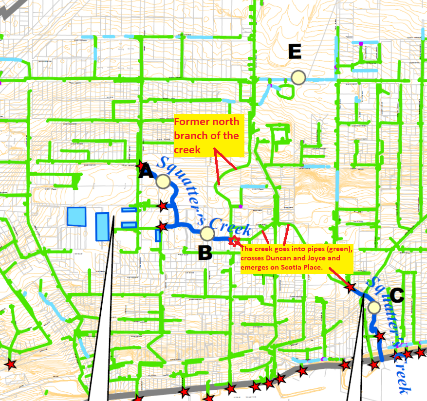
There isn’t much of Squatter’s Creek left above ground, as the map below illustrates.
The blue lines are the daylighted portions of Squatter’s Creek; the underground sections are traced in green; our old branch entered just where the upper daylighted section goes into the storm sewer. (Westview Watershed Drainage Master Drainage Plan, 2007: Drainage Overview Figure 3-1.)
Today, the creek above Joyce and below Joyce are entirely different watercourses.
Upstream
The western branch, which once drained swampy land east of Alberni Street, now drains the runoff from the various parking lots of the Town Centre Mall, Hotel, and apartments. The daylighted section of creek just downstream collects water from those parking lots, mixes in a little spring water from further up Barnett and runs along just above Joyce until it enters another storm sewer behind the Salvation Army. That water is pretty clean and still supports a small trout population with attendant raccoons and blue heron.
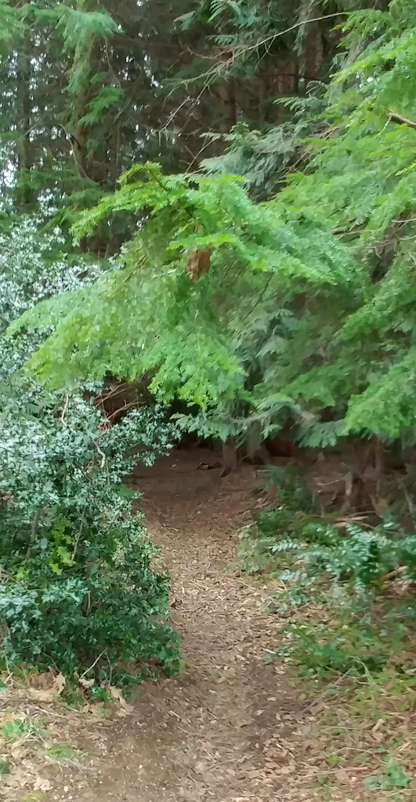
Last spring my brother and I went to check it out. On our first trip, we entered from behind City Transfer’s back lot. The edge of the bush had all the hallmarks of such places in the middle of towns everywhere. An abandoned grocery cart, a bulldozed pile of old lumber, a few plastic bags.
But once we passed through the transition, trails appeared.
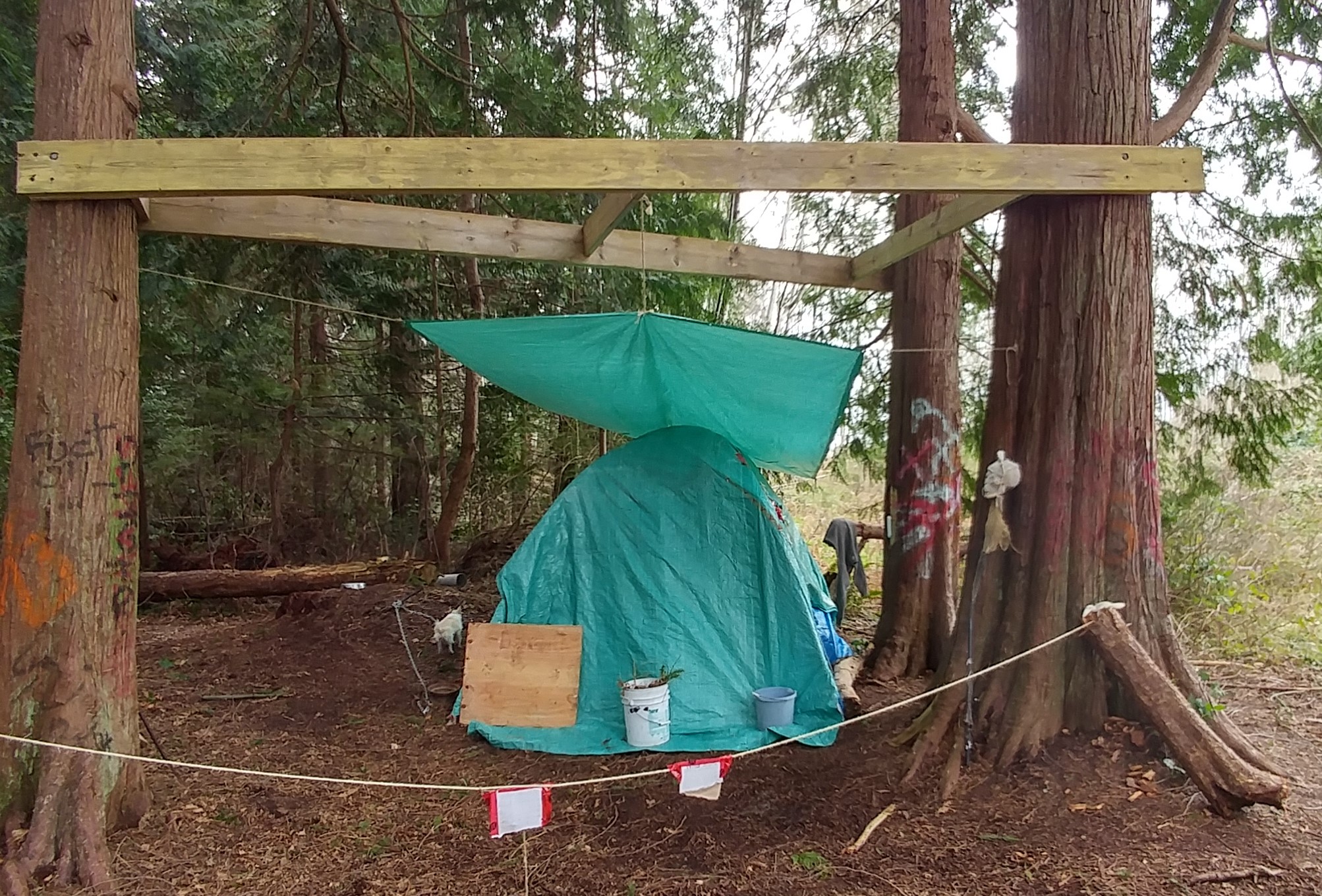
We both tried to feel our way into it, to remember the feeling the forest gave us, but it didn’t happen. The creek is buried, and the distance created by the lives we’ve each lived in those fifty years have, at least for me, erased all but a very few sensory memories.We followed the trails over to where the upper section of the daylighted Squatter’s Creek curves around the edges of parking lots and backyards near Barnett. We found one tent near a grassy opening.
The bush was tidier than expected – we’d heard people partied in there but there was very little garbage. A few days later we went back in to try to further trace the creek’s passage, entering right behind an apartment block on Joyce and met Michael Gelber, one of the reasons there’s very little garbage. He lives at the top end of the bush on Redonda and walks it pretty much daily with his dog, Arena. When we met him, he’d just moved a cracked safe out of the creek – likely a stolen one that had been carried out of sight before being broken open.
He took us up the creek, pointing out the culverts that spout out of the parking lots, and along the top end where water seems to seep out of the ground. He explained the different plans people had made for the mixture of private property and town lots: apartment blocks, a new firehall, and the bike jumps, well-used before the bike park was built beside the rec complex. And yes, there used to be a homeless encampment in there before the qathet Supportive Housing building was opened at Joyce and Harvie.
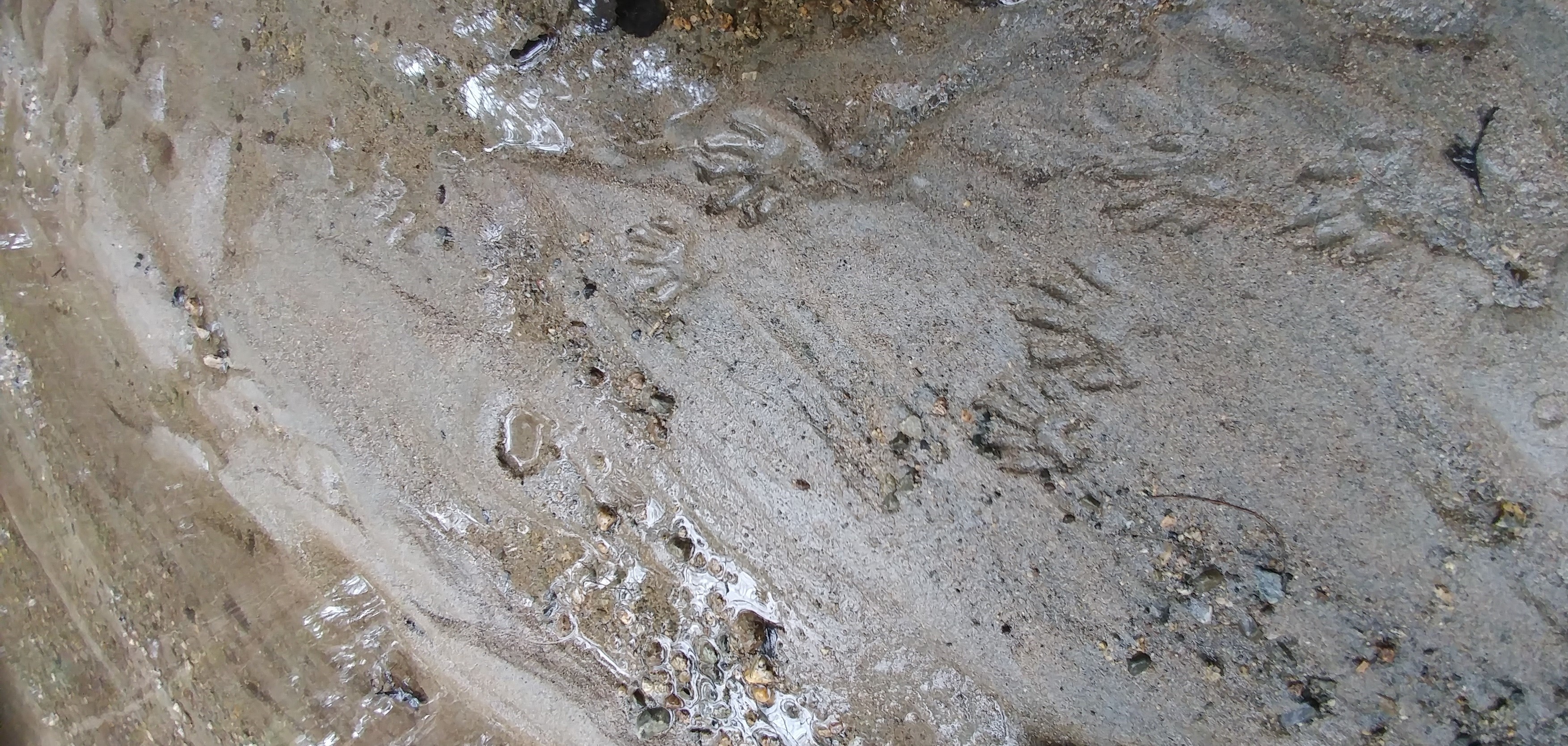
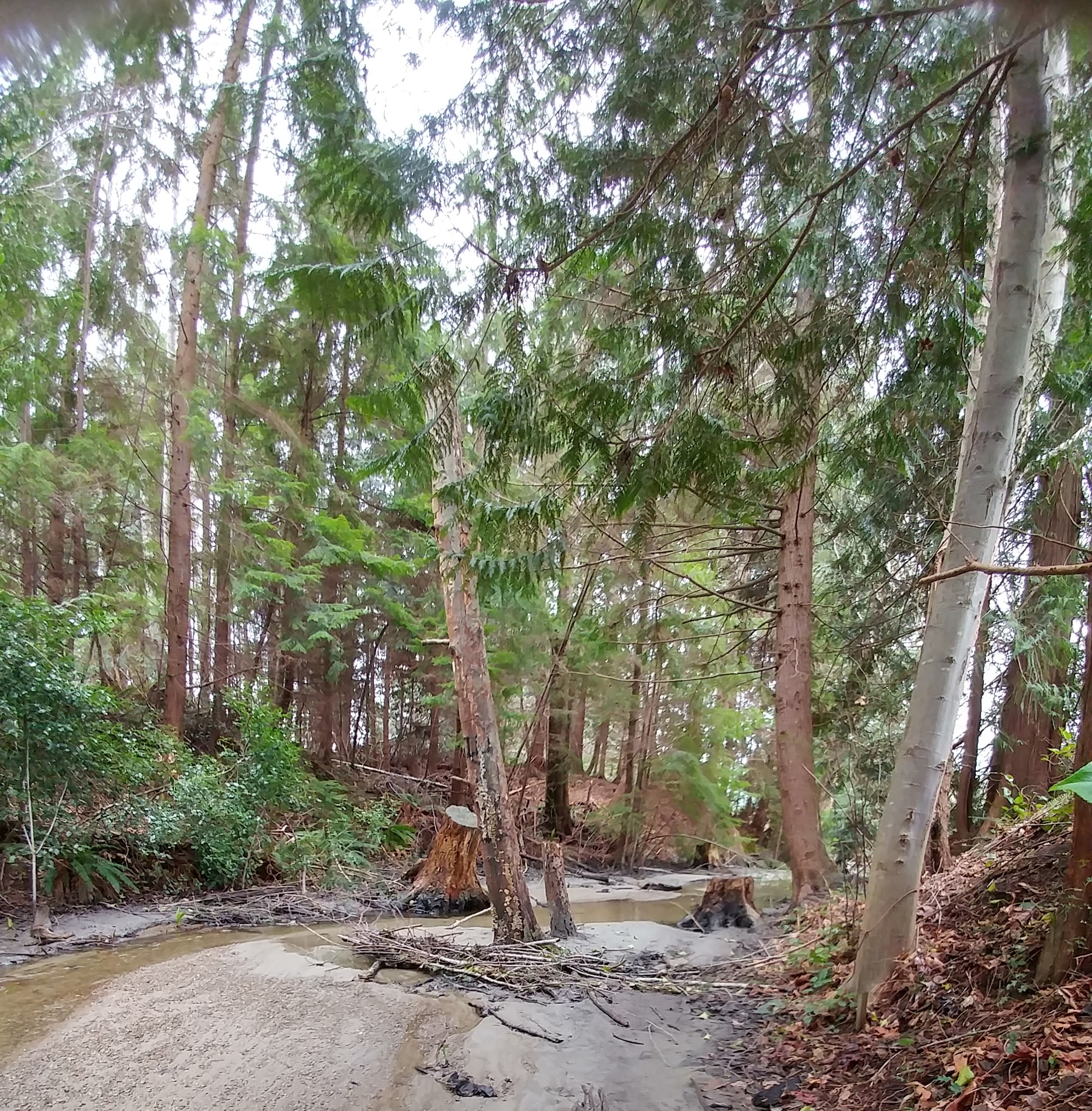
A few days later, Herb and I went back in with our gumboots, ready to trace the creek down to its lower culvert. It was both enchanting and disheartening. The creek made some nice sweeping curves with sandy banks and we found racoon and heron tracks, the heron tracks supporting the claims there are fish in there (we looked, but didn’t see any).
But as the creek turned to run along behind the houses on Joyce, it was a tangled mess. Blackberry vines, rotten bridges, garbage, old fences, some falling apart. But there are still signs of children playing there, even a kind of zunga.
And then it disappears into a culvert behind the Salvation Army.
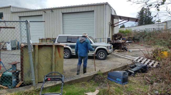
We followed a muddy path up into what seemed an industrial wasteland of abandoned equipment, chain-link fences, and cracked pavement at the end of Franklin Street, much of it part of the old MacIntosh & Norman site. A few offices tucked into corners of what looked like vacant buildings. A spooky apocalyptic film set in the middle of town.
But those initial impressions are wrong. We took some friends through there last week and ran once again into Michael Gelber and Arena. He talked about how wonderful it had been in the summer to see kids playing in the creek. We wandered through the MacIntosh & Norman site and met up with Jordan Arnold, who owns it now. He is, he says, slowly cleaning it up. His mother lives on the other side of the creek and he built a new bridge across so he can pop over to see her. Sometimes pausing to let the bears that enjoy this refuge pass first.
Downstream
Downstream, Squatter’s Creek emerges from the storm sewer just below Scotia Place into the same ravine my sister scrambled down with her little piece of paper. It’s the storm sewer that collects the water flowing under the old landfills and is no longer clean. Ironically, it is this stretch of creek that is much more picturesque. Just before it crosses under Westview Road, it passes through Diana Woods’ lovely Boxwood Cottages and Gardens. Our son and daughter-in-law stayed there when they got married three years ago; it’s a wedding photographer’s dream.
Diana showed me around her place last spring.
Boxwood Gardens in April
The April flowers were in full bloom, blossoms falling from the big flowering cherry tree, birds singing. The gardens flower year round, she said: the camellia blooms in November, December and January and the daphne comes into flower in February. After that comes the riot of spring. And the creek sound is everywhere.
The gardens are a work in progress, as all great gardens are. Gorgeously placed shrubs, stone walls, fences and flower beds don’t hide the implements used to make them, a gas can for the mower, shovels, a rake. Diana likes to use the things she’s grown. Cedars planted years ago are now the posts used to build a small bridge over the creek with a path up to a meditation building. Bamboo canes cleared from overzealous spreading have been used to make a beautiful deer fence around her vegetable garden.
Diana in her vegetable garden.
Her house was built by Glen Husband’s (Tom Pickle’s friend) parents in 1932. Diana moved nearby in the early eighties and became friends with Mrs. Husband. “I had a good feeling about her.”
But it was the creek that drew her to purchase the property from the family in the mid-eighties. She tried to cut a path through the mass of blackberries and alders down to the creek but had to bring in a backhoe and excavator. She worked with the operator – he’d dig and she’d haul out the enormous blackberry roots. “I’m not afraid of machinery – I studied landscape at UC Davis in California,” she said. They had to build terraces down to the creek so they could get out all the garbage including a bed frame and car doors.
She loves the sound of the water, but Squatter’s Creek is not without its challenges. She had the water tested by a friend who said the water has a thousand times the amount of iron that’s safe. The sand beside the creek and the water itself often runs red. The smell is sometimes bad. When she contacted the Ministry of the Environment, she was told it would eventually clean itself out. To dilute the concentration, Francescutti told me, the town actually re-routed some of the contaminated water underground and diverted some cleaner storm sewer drainage into the current creek bed.
Just before the creek crosses Marine to plummet down under the seawalk and into the ocean, another home has incorporated the creek into its garden with a small bridge crossing.
When it finally enters Malaspina Strait the creek creates brackish pools much favoured by preening gulls, ducks, ravens and crows.
I realize I’ve been trying to give this creek heroic proportions. It isn’t like Driftwood Creek, the creek I used to live beside, with its dozen bridges, mining claims, farms, salmon, dippers, harlequins, frozen pathways for skis, home to fossils, berries, creek walking.
As Tom Pickles said when he and his wife Shannon walked through the bush there with us, it is pretty small.
My brother, Herb (left) and Tom.
But it’s got such possibilities. Perhaps development on the upstream part will incorporate the park-like qualities of the trees, the sweep and slide of the creek itself, or will make a small linear park for people in the neighbourhood. Perhaps one day the iron and methane leaching out of the old dump sites will be done and the lower creek can run clear again. There are many pieces of bush throughout town, some have been there as long as I can remember. Neighbourhood kids and wildlife make paths through them and find shelter there. The millennial trails have two fine little creeks running through them. But this stretch of woods right in the middle of Westview, with its tiny creek, feels like something worth cleaning up, worth hanging onto.
Further comments:
My sister shared some more memories after reading the post:
Right next to where the Moran’s lived in the little house below us, there was an area with lots of scrub and small trees and I remember I used to go and sit under the canopy of alder leaves and branches beside what must have been the remnants of an old beaver dam. There was a little bit of a stream bed or pond bed … about 4 feet long … in the land and although no water was moving or visible most of the year runoff water would collect in it in the fall. It felt like a magic place to me. I always felt very safe there and the moist air made me feel so good.
It may have been a water way that ran into Squatter’s Creek which would have been directly below it behind the old bus depot.
I can not remember if it disappeared when they cleared the Max Cameron field area or when they built the house next to Moran’s place when I was in my early teens.
John Mee also added a beautiful word image – thanks John.
We lived on the corner of 5th [Egmont]and Michigan before J.P. Dallos school was built, so Squatter’s Creek was a very big part of our everyday activities. I remember the three bridges in our area, the one on Duncan Street which remained standing long after Duncan Street culvert was put in and the new road was complete. The second bride was located on Joyce just south of 5th Street , the third bridge was located on Old Westview Road in front of Bob Lyons family home. Fish were abundant and trees were filled with birds and squirrels, yes even flying squirrels and large red-headed [pileated] woodpeckers. It boggles the mind how city officials would come up with an idea to fill this beautiful stream with garbage.
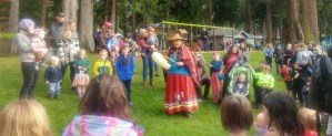
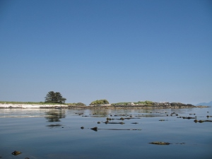
Sunday, we joined about 200 community members in Powell River on a reconciliation walk organized by the hɛhɛšin movement.* The walk, honouring the children of residential schools, began at Willingdon Beach and ended at the Westview wharf. Other participants were there to remember missing and murdered Indigenous women. All were there to take steps on a path that will bring us all to a greater understanding of and respect for Tla’amin and other Indigenous traditions.
Standing on the grass at the beach where my mother used to swim when she was a child, where she brought us when we were children, and where my own sons and grandson have played on family visits connected me to this place I am learning once again to call home.
It was just over a year ago when we still lived in Smithers that our publishing company, Creekstone Press, celebrated the launch of Shared Histories by Tyler McCreary with the Walk to Witset. Shared Histories detailed the history of Witsuwit’en life in Smithers and placed the racism they faced in a provincial and national context, one that applies to the Tla’amin people and Powell River as well. Smithers was a railway town; Powell River a paper mill town. In the early 1900s, each corporation planted a townsite on Indigenous territory without consultation or accommodation. Many of the subsequent settlers and their elected representatives took concrete steps to exclude the land’s original owners from the new communities.
The committee of Witsuwit’en elders and Smithers’ settlers who contributed to Shared Histories wanted to host a book launch that truly marked the process of truth and reconciliation. The book itself detailed some of the truth Smithers’ residents needed to discover, and the walk became a symbolic journey of reconciliation. Smithers’ then mayor Taylor Bachrach and Witset’s chief councilor Misilos Victor Jim joined dozens of others to walked the entire 34 km of Highway 16 that links the communities. The balhats or feast that welcomed them to Witset served over 400 people, more than half non-Indigenous. The book went on to win the BC Historical Federation’s 2019 prize for historical writing.
At Willingdon Beach, Rose Henry began by gathering the children around her to sing a song honouring them as ancestors, explaining that the Tla’amin believe (as do the Witsuwit’en) that children are their elders come back.
Cyndi Pallen (čƖnɛ) spoke about the origins of the walk, how members of the non-Indigenous community reached out to continue the work of bridging the gap between communities. John Louie (yaxwum) blessed the gathering with a prayer in Tla’amin reminding us that children in residential school were beaten for using their language: he asked that we all pray in our own way and respect the way others pray.
Along the route, we stopped to hear a woman’s warrior song, we sang together as we walked, and the group finally gathered at the Westview wharf, beside the Comox and Texada ferry terminal. I remember the wharf as an intimidating landmark for my younger self; it rises high out of the water and older kids fished off it, the braver ones jumped off it. For many Tla’amin children, John Louie told us, it was a place of great pain, the place where they were put on the boat that took them to residential school.
Walking and singing together lifted our spirits. We are beginning to recognize faces, to remember names. Our new home has every right to be proud of its efforts** to build connections between its communities and we are honoured to join in those efforts.
* hɛhɛšin is an ongoing grassroots reconciliation movement that started with a mixed group of non-indigenous people from the Upper Sunshine Coast, that wanted to reach out and connect with the indigenous people of this land, by honoring the teachings and territory of the Tla’amin people.
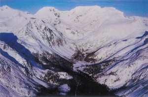
Don Parmeter’s aerial photograph of the Driftwood Creek headwaters.
The concept of watersheds has long fascinated me, as the many posts about Driftwood Creek illustrate. Back in 1977 when I worked for a Terrace newspaper, a regional district staffer, Doug Aberly, suggested provincial programs be managed in integrated watershed districts rather than in the piecemeal way jurisdictions were and still are divided. Long before that, Indigenous nations divided territories along geographical lines of watersheds rather than the methods used in Canada’s Dominion Land Survey system which created townships and one-mile square sections of land, completely ignoring the natural boundaries provided by creeks, rivers, and mountains.
Years later, I opened a play, The Height of Land, with the image of a woman squatting to pee (women’s attention is more focused on the ground between our feet at these moments) and wondering which way her urine would run – if she was in just the right place (like the Columbia Icefields) could her urine eventually reach three oceans? A shift of inches could produce an entirely different outcome – a little like that butterfly flapping its wings in Beijing.
Then I took a geography course from Rick Trowbridge at what was then Northwest Community College. He showed us a short film that began with the image of a single drop of water splatting onto the ground. Whether it was soaked up, frozen, evaporated, or ran into the nearest stream, it eventually returned to the sea via one watershed or another. While the term height of land sounds as if it should stand out – a hill or mountain – it is often the opposite. Think the country north of Prince George along the nine-mile Giscome Portage where the watershed shifts from the Fraser to the Peace (via the Crooked and Parsnip rivers). Nothing dramatic there. And Rose Lake just west of Burns Lake, the division between the Fraser and Bulkley/Skeena river basins. Again, hardly a hill in sight.
Driftwood Creek’s beginnings are a little more dramatic where the watershed shifts from Driftwood Creek and the Bulkley to Cronin Creek and the Fulton and Babine rivers. A sensible boundary between Witsuwit’en and Nedut’en territory.
Lynn and I scrambled up above the cabins in Silverking Basin in 1977 on our first extended camping trip into the Babines. We fought the shintangle to reach the small lakes in the basin whose walls create one of the boundaries between those watersheds and also between Silverking and Grassy Mountain and the Twobridge (Reiseter) watershed.
Dan, the Rhebergen girls and Gisela Mendel.
Our eldest son, Daniel, went with me and Gisela Mendel in 1991/2 on a weekend trip into the basin. We joined Frank Rhebergen and his daughters to climb up the shintangle again into the headwaters. We made it up onto the flank of Cronin and crossed over to the Hyland Pass Trail – a route we tried to do in reverse the summer before last. We didn’t succeed, so Don Parmeter very kindly gave me the beautiful aerial photograph at the top of this post.
The kids with Silverking Basin and Harvey Mountain in the background.
Me and Dan below the glacier.
Lynn and Jim Pojar on Grassy Mountain, the Fulton side of the watershed divide.
All those watersheds draining into the Skeena Basin, into the Pacific Ocean.
And now we live right beside the same ocean. Here many creeks run straight to salt water without a river in sight. It’s a new kind of geography. For a river to get big, it needs to start far away from its final outlet. Once you think about it, it seems obvious, but coming originally from Powell River as I do, I didn’t really understand rivers. Powell River, the river that is, is one of the shortest in the world. Maybe that’s why I ended my novel, The Taste of Ashes, beside the Nautley River which drains Fraser Lake a mere 800 metres before it empties into the Nechako. Another “shortest” river. It felt something like home.
My chapbook of poetry – The Bathymetry of Lax Kwaxl– is being launched, quite literally, into the Bulkley River this coming weekend – the day before Mother’s Day by chance. We are going to fold the poems into boats and send them down on their way to Prince Rupert. As we made plans for the launch I remembered this piece I wrote many years ago to honour my mother, who still lives beside the beach where we gather to swim – she’s coming up to 92 years old. “On Folding a Rowboat” was published in a Prince Rupert anthology called North Coast Collected (thanks to Jean Rysstad for choosing it) in the early 1990s.
I sat at my kitchen table laboriously folding an origami rowboat. I had bought a book demonstrating the nautical equivalent of the art of folding paper airplanes. Ostensibly for my children, the book was really for me. I love following the instructions, figuring out the folds and angles, producing a perfectly engineered ship from a leftover scrap of paper.
I needed an excuse, however. A Mother’s Day present lay waiting to be wrapped, and I decided to decorate it with paper boats. So, naturally, I started thinking about water, my mother, and – inevitably – swimming.
I was a child and the sea was home to my body. Its salt supported me as I thrashed my way to buoyancy; it cleansed my scrapes and cuts; it washed illness away. My mom never took us to the beach and said, “Now, don’t get wet.” Yes, I have seen this, have heard parents tell their children they can’t go swimming because they have a cold. Or it wasn’t warm enough.
Why were they there, I wondered, if not to swim? To torment their children? I was an adult before I understood that people go to the beach for reasons other than swimming.
My family firmly believed that swimming in the ocean, even in cool water, was a tonic; refreshing and curative. It would certainly never cause any harm.
Perhaps I should clarify here that it was my mom’s family, weaned on North Sea beaches, that made the summer evening trips down the terraced streets of Powell River to the beach. Since we lived farthest away, my mom would begin the walk with just the three of us kids in tow. On the way down towards the water we would pick up Granny, and sometimes Grandpa, and then join our aunt and her three children at the beach just below her house. But the sons-in-law, men who worked outside on log booms summer and winter, day shift and night shift, were intent on keeping their bodies out of the salt chuck; it would take more than a warm, idle summer evening to re-route those neural paths.
Unnecessary modesty was scorned on these outings. We changed behind boulders or the massive roots of beached cedars, struggling to pull clothes over damp salty skin before a shielding towel fell or was blown away. My grandfather would change beneath a towel even at the most public beach on a Saturday afternoon. One summer, while his wife was back in Scotland, my mom had to force him to buy a new bathing suit; his old one was so full of holes it was no longer decent. In his late seventies at that time, thin, wrinkled, and almost blind, he appeared the next day in brilliant blue satin trunks, their cut clearly intended for young hunks. It was, I think, his last bathing suit.
As I grew and was exposed to a wider array of summer social activities, I was astonished to discover that many people didn’t like to swim at all, and of those who did, most preferred lakes. As wealth grew, swimming pools.
As for myself, I have never trusted fresh water. Not even swimming pools. The sight of small children toddling along the slippery tiles, a stumble away from eight or ten unforgiving feet of bleached water, makes me cringe. What will happen if I leave before their sundazed parents wake up? Or if the lifeguard is distracted by a teenage commotion?
But watching children play beside the ocean is as comforting as seeing them curled up, dozing in the sun against salty women’s skin.
The beach at the bottom of Third Avenue where we used to swim was protected and benign. I could not fall in off the edge; at high tide there were no sudden drops, just enough slope so the water got comfortably deep before I was too far away from my mom for reassurance. The ocean could not carry me off because each wave pushed me back to shore. Its secrets were revealed at every tide’s ebb, its furtive crabs and limp slippery weeds, its smooth stones and gravel washed twice daily, as orderly as my own ablutions.
There were no rip tides, no undercurrents, just waves, logs to ride and dive from, and buoyant salt cradling young bodies. It seemed to me the only people the ocean claimed were those foolish enough to go too far from shore, and then what could you expect? Storms, too much drink, holes in boats, these killed people. Not swimming.
Because we live so far from the ocean now, and my need for immersion is so strong, my children learned to swim in lakes. But growing comfortable with lakes has taken me years. There were oceans for swimming and puddles for puddling. On the clearest calmest day the ocean never reflected anything but fractured light. Lakes, being fresh water, were closer, in my family’s pantheon, to puddles. Not entirely clean and reflecting a different kind of light. A child peering in, wonders how deep is this puddle, are my rubber boots tall enough or will the water rise to slip over the rims? Then seeing the whole sky waiting in that calm reflection, the depth unimaginable, the child teeters terrified at the edge while feeling that pull down, down into the sky.
Haslam Lake, one of the lakes of my childhood, was like that. Still, limpid water reflected trees that crept right up and hung over its edges.
As for unclean, well, it’s not really fair to call Haslam Lake dirty – it supplied much of the town with wonderful drinking water. But when I was younger and still afraid of lakes, its squishy bottom, sludged stones, and logs dead beneath the accumulation of eons sent a ripple of distaste up my spine. Like cold, greasy cutlery at the bottom of a sink full of forgotten dishwater.
To avoid the ooze, we’d swim at a gravelly patch of shoreline resembling the seashore at high tide. And here the lake revealed its true nature; it was a cheap trick, a watery imitation lacking substance and buoyancy. Floating took effort; concentration wavered into floundering panic. All confidence in my fledgling dog paddle dissolved in flailing, sputtering indignity. Because of this, I disliked lakes. As well as muddy, tangled with weeds, hiding leeches of legendary awfulness, they were mean-spirited and dangerous.
Sometimes my mom took us to Haslam Lake fishing – not often, but once or twice. We’d rent a rowboat from a man with goats – the only person who lived on the lake. He must have lived there for years, before people worried about water supplies and had referendums on fluoridation. We rented the rowboat for forty cents an hour, $1 for two and a half hour’s fishing. Plenty of time.
I don’t remember anyone catching fish. Mom would tell one of us to be ready to take her line if the fisheries officers came by, but I never saw a fisheries officer deal with anything as insignificant as fresh water until I moved here to the Bulkley Valley, where salmon and those elusive steelhead battle their way beyond the tides, past the jealousy and treachery of fishermen and sloughing riverbanks.
The road to Haslam Lake was gravel and darkened by overhanging alder and salmonberry bushes. Above this impenetrable barrier the cedar and hemlock pressed in. Other roads led off to marshy Duck Lake and beyond to the preserves of more serious outdoorsmen. But the road to Haslam Lake curved left past the filtration dam, past the goat farm. It wasn’t a real farm, just a shack on a strip of land between the lake and the road, a strip of stumps and logs strewn across bright mossy grass cropped close by the goats. The goats would assume crazy perches on the stumps and run nimbly through the debris as we drove down to the dock of silvered boards.
When we were a little older, we’d ride our bikes up to Haslam Lake to fish or swim on our own. Later still, equipped with driver’s licenses, we’d drive up there in our robin’s egg blue 1960 Vauxhall station wagon with forty (“count them!” we’d laugh) horsepower. It was our first car. My mom and all of us kids learned to drive in it.
Braver now, we’d follow a narrow path to swim back beneath a rocky bluff. This was the place where Neil Mackenzie dove and broke his neck like in a gruesome summer safety film strip. Or was it his back? But he lived and walked and married and has children – I never did understand about broken necks and backs – I always thought it was instant death or paralysis, and yet there are people alive and seemingly well…
We measured our nerve, our maturity, against swimming holes. Powell Lake was a step up. It was a home fit for all the monsters of a child’s imagining. Swollen by a dam and spotted with deadheads, it was deep, prehistorically deep. Some claimed that there was salt water trapped at the bottom beneath layers and layers of unmoving lake water. And I remember hearing there were spots where they couldn’t find the bottom at all. I would imagine skillful, serious men out there in a rowboat, paying out mile after tedious mile of thin line, taut and heavy as it was pulled down into the sky reflected in the lakecalm surface.
Let’s face it. Lakes are creepy.
But they’re amateur freshwater villains compared to silent, sliding rivers. My children play beside and fish in the Bulkley River, one that has claimed many lives on its sweep to Prince Rupert. There are countless stories of fishermen slipping off its treacherous rocks; a mother’s nightmares lurk beneath the mercury sheen of its water.
There is a story of a woman parking on the river bank across the road from a pay phone. Leaving her sleeping two-year-old in the back seat to make a short call, she returned minutes later to find his footprints on the other side of the car, leading to the edge of the ice.
They never found him.
I remember reading another story of a man, helpless, watching his young son slip off a bridge into a river just east of here. He, too, was lost.
I know these sound like stories invented by nervous mothers to frighten children into obedience. But they were reported in the local paper; they are not parents’ imagined terrors. No imaginings can outdo what really happens.
So I clutch my children’s hands as we stand and peer off bridges and cliffs into the river to see spawning salmon. And, as they grow older, I try to swallow my fear and recreate the same waterside peace my mom gave to me. One spring day I had to walk away as their father stood with them on a bridge throwing stones into the creek far below – walk away with my hands shoved deep into pockets to keep from grabbing them, pulling them from the edge.
You see, lakes are bad enough, but I’ve had no practice with real rivers, no practice at all. Powell River, the town, has no seriously moving water. There were only two bridges I can recall, both over rivers dammed to produce hydroelectricity for the pulp and paper mill. One spanned the memory of Powell River itself, swallowed between the dam above the mill and the brooding lake. The other crossed the shrivelled remnants of Eagle River on the south end of the forty miles of highway between Lund and the ferry out of town, the boundaries of our restlessness. Eagle River drained a chain of lakes filled with ghostly trees, erect and dead in the water.
Below the dam, what remained of the river trickled through swimming holes joined by waterfalls, surrounded by cliffs. This is where we came when hormones sent us jangling down the highway on summer afternoons. By then we were crammed into a friend’s Volkswagen, listening to Paul McCartney’s “Lalalalalalalovely Linda.”
It was upstream in this same river, in a frigid pool, in the tumble of huge debris just below the dam, that we proved our sophistication by swimming naked. Perhaps swimming is overstating it. The leap from rocks to water lasted longer than the panicked scramble to reach shore and huddle shivering under towels.
But behind these tame river adventures was the knowledge the warning horn could go off at any second signalling a release of water from the dam, turning the emasculated trickle into its true river self, a spectacle none of us had witnessed.
The fear was real. One time we climbed back through the bush to the dam itself and walked across. No hand railings shielded us from the bulk of water it restrained, from the terror of the long concrete sweep to the sharp jumble of boulder far below. So we played with one ear alert for freshwater treachery.
I never did hear that horn, and I realize now there was little likelihood of ever hearing it in the dryness of summer. But who thought of such things then? The town faced the ocean and its water levels were as predictable as the moon. We had no knowledge of the ways of rivers.
So, the familiar ocean was where we went for safety, to hide from adults, light fires, talk, drink and swim in the warm black summer phosphorescence. The beach was a path you could walk without fear of ever getting lost.
Every family has its rituals for reassurance. In ours, getting dunked is matter of ceremony and virtue. There are clear rules, procedures. If one toe goes in the water, the rest of the body must follow. Or rather, if you get your bathing suit on and go down to the beach, you have to get wet, even if you don’t stay in.
I do my best to maintain this tradition, and make a point of swimming wherever I can. I have swum in the Atlantic and the Pacific, the Mediterranean and the Caribbean, the Aegean and the Andaman, the Gulf of Mexico and the English Channel, the Bay of Biscay and the Adriatic, the Tyrrhenian and the Ionian, the Straits of Juan de Fuca and Malaspina, the Gulf of California and the Yucatan Canal, Hecate Strait and Desolation Sound. Overcoming my freshwater prejudices, I have swum in Lakes Ontario, Huron, and Superior, though I’m afraid of the polluted soup of Lake Erie. (If its water had been salt, however, I may well have held my nose and swam.) I have shrieked and shivered in countless glacial streams and lakes. I have even swum in back eddies of the Bulkley River, though I cannot bear to watch my family fish at its edge.
I have a friend who shares this desire to swim in every body of water that presents itself. We used to have our most intense conversations treading water out beyond the reach of our children splashing on the shore. But they too are getting old enough to swim out and join us in talk, comfortable even in fresh water.
When we go to visit my mom, who now lives right at the ocean’s edge, I laugh as my children make disgusted faces at the taste of salt; I laugh as they delight in its generous buoyancy, push heavy logs free with the help of the encroaching tide and ride them on the wonderful warm (well, once you get used to it!) southeasterly waves.
All of us go in with my mom, in the evening before dinner. It is ridiculous, this virtue we make of swimming. But we still stand, exhilarated and salty, shaking our heads in astonishment at the fact that although there are dozens of houses along the choice waterfront, the beach is empty. And later, my mom, still in her bathing suit, stands dripping on a towel in the kitchen, mashing the potatoes that boiled while we swam. For a moment, the quiet clutch of fear that underscores all the pleasures of spawning children relaxes in the aftermath of ritual in my mom’s house beside the ocean.
Kathaumixw is a Coast Salish word – a gathering together of different peoples – and is the name given to the international choral festival that has been held every other summer in Powell River on BC’s Sunshine Coast since 1984.
I grew up in Powell River and my mother still lives here, but this is only my second visit to the festival. My own United Church experience of choirs was pretty stodgy, though I do remember when Frank Bemrose sang O Holy Night at Christmas, shivers ran up my spine. It was his wife, my Grade Three teacher, who suggested I just move my lips when we sang at the Christmas concert. In spite of her, I used to lie in bed at night singing my heart out for the talent scout I knew was hiding in the closet so as not to make me anxious.
It wasn’t until I joined the Smithers community choir, Local Vocals, that I realized what powerful emotions are given expression in a choir. Mrs. Bemrose was right; I am not a strong singer. But surrounded by a cluster of talented altos who are very friendly about nudging me up or down the scale when necessary, I think I do okay. Well, mostly. There are days when it’s hard to batten down the jealousy I feel when those special voices ring out true and clear around me.
Kathaumixw is truly the perfect word – this festival is rich in musical differences. Each choir has its own personality: some are controlled, the singers barely moving, the voices the only projection coming from the group. They lean slightly forward, eyes on the conductor, attentive to every nuance of tone, tuning, blending and dynamics.
Other choirs are pure energy. They move and clap and laugh, visibly enjoy the sounds they are creating, the peculiar calls and responses the composer calls for, the clicking and whistling, the honking of small horns, the yodels and thunderstorms. These are not stodgy, these choirs, they are not stuffy. They can belt out an African-American spiritual, hollering and stamping. And somehow forty singers can hush down as quiet as a mother bending over a sleeping child.
But while I love to sing, I’m a writer. And however well a choir’s voices blend, you can find a Russian novel’s worth of characters standing side by side on the risers. As the music flows through them, you can see that big man on the left with the goofy hair is singing from some deep soulful place; the skinny little soprano who’s always smiling probably brings cookies to rehearsals. The middle-aged alto reaches out a hand to the baritone beside her. He steps closer to put an arm around her as the song reaches its crescendo. Afterward, he bends to her, she nods and steps away. Some crisis averted. Plot potential abounds.
The children’s choirs are miracles of diversity: one girl with dead straight black hair that sticks out like she’s taken part in a science centre’s high static demonstration; a little guy, can’t be more than six, has a dozen cowlicks, his exuberance barely contained. Beside him, a girl with tight pigtails stands apart, her mouth barely opening, the notes squeezed out through some powerful resistance. As a young women’s choir – a kind of finishing school for young ladies of the eastern seaboard – walks onto the stage, one girl sails out, large and calm, her hair bright pink, the only colour in the pall of ashen gowns and decorous hair.
As all these shapes, sizes and personalities sing, you can feel they are changed by the music and you know the music is changed by them. Some are struggling with technical difficulties, perhaps. Others might be reliving the heart-breaking memories of a winter’s night. When they belt out Hallelujah, one is maybe thinking how she’d like to kill the conductor for not giving her the solo. One is trying not to throw up from nerves or a hangover, one is pregnant, another has just miscarried, a grandfather has just heard that his daughter is leaving her husband and, for each one, the song tells a unique story.
As a writer, I find myself lost in their faces, their postures, their gestures and stances. With singers from Asia, Europe, Africa and New Zealand and North America, they literally encompass the world. There are a thousand unique characters that will gather tonight for the final massed choir singing of Oscar Peterson’s Hymn to Freedom and running through them all flows the great river of music. How could a writer not be jealous? How could a writer not be inspired?
On the road with The Taste of Ashes, I gave readings in Campbell River and Powell River. I always enjoy these conversations with book lovers – thanks to those who attended.
I also had an interview with Sheryl Mackay of CBC’s North by Northwest weekend arts and culture radio show – she’ll be airing the interview Saturday, Sept. 8 just after the 8:30 news.