Beginnings – the height of land

Don Parmeter’s aerial photograph of the Driftwood Creek headwaters.

The concept of watersheds has long fascinated me, as the many posts about Driftwood Creek illustrate. Back in 1977 when I worked for a Terrace newspaper, a regional district staffer, Doug Aberly, suggested provincial programs be managed in integrated watershed districts rather than in the piecemeal way jurisdictions were and still are divided. Long before that, Indigenous nations  divided territories along geographical lines of watersheds rather than the methods used in Canada’s Dominion Land Survey system which created townships and one-mile square sections of land, completely ignoring the natural boundaries provided by creeks, rivers, and mountains.

Years later, I opened a play, The Height of Land, with the image of a woman squatting to pee (women’s attention is more focused on the ground between our feet at these moments) and wondering which way her urine would run – if she was in just the right place (like the Columbia Icefields) could her urine eventually reach three oceans?  A shift of inches could produce an entirely different outcome – a little like that butterfly flapping its wings in Beijing.

Then I took a geography course from Rick Trowbridge at what was then Northwest Community College. He showed us a short film that began with the image of a single drop of water splatting onto the ground. Whether it was soaked up, frozen, evaporated, or ran into the nearest stream, it eventually returned to the sea via one watershed or another. While the term height of land sounds as if it should stand out – a hill or mountain – it is often the opposite.  Think the country north of Prince George along the nine-mile Giscome Portage where the watershed shifts from the Fraser to the Peace (via the Crooked and Parsnip rivers). Nothing dramatic there. And Rose Lake just west of Burns Lake, the division between the Fraser and Bulkley/Skeena river basins. Again, hardly a hill in sight.

Driftwood Creek’s beginnings are a little more dramatic where the watershed shifts from Driftwood Creek and the Bulkley to Cronin Creek and the Fulton and Babine rivers. A sensible boundary between Witsuwit’en and Nedut’en territory.

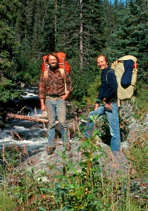
Lynn and I scrambled up above the cabins in Silverking Basin in 1977 on our first extended camping trip into the Babines. We fought the shintangle to reach the small lakes in the basin whose walls create one of the boundaries between those watersheds and also between Silverking and Grassy Mountain and the Twobridge (Reiseter) watershed.

Dan, the Rhebergen girls and Gisela Mendel.

Our eldest son, Daniel, went with me and Gisela Mendel in 1991/2 on a weekend trip into the basin. We joined Frank Rhebergen and his daughters to climb up the shintangle again into the headwaters. We made it up onto the flank of Cronin and crossed over to the Hyland Pass Trail – a route we tried to do in reverse the summer before last. We didn’t succeed, so Don Parmeter very kindly gave me the beautiful aerial photograph at the top of this post.


The kids with Silverking Basin and Harvey Mountain in the background.


Me and Dan below the glacier.


Lynn and Jim Pojar on Grassy Mountain, the Fulton side of the watershed divide.


All those watersheds draining into the Skeena Basin, into the Pacific Ocean.

And now we live right beside the same ocean. Here many creeks run straight to salt water without a river in sight. It’s a new kind of geography. For a river to get big, it needs to start far away from its final outlet. Once you think about it, it seems obvious, but coming originally from Powell River as I do, I didn’t really understand rivers. Powell River, the river that is, is one of the shortest in the world. Maybe that’s why I ended my novel, The Taste of Ashes, beside the Nautley River which drains Fraser Lake a mere 800 metres before it empties into the Nechako. Another “shortest” river. It felt something like home.


Silverking Basin

by Harry Kruisselbrink

Harry has lived in Smithers since soon after his family arrived in the Bulkley Valley in early 1951. He served on town council for many years and was a dedicated environmental activist and researcher. He is a wonderful photographer (the photos here are from his collection) and has helped record local history, working with Lynn Shervill on Smithers: From Swamp to Village and writing his own Smithers: A Railroad Town. He is also a great friend. Like many of us, he can’t help returning, year after year, to the beautiful Silverking Basin where Driftwood Creek begins its journey to the Pacific.


Harry and Juanita

By the late 1960s, Audrey and I had been to Silverking Basin quite a few times before we had the kids. Once we had them, it became a little harder. Leroy was born in 1966 and Juanita in 1969 (Charmaine was still four years down the road). It then occurred to us that we could actually take the kids into the basin and stay for more than just the day. The first time we did that was in July 1970. Leroy was a three-year-old getting close to four. Juanita was a year-and-a-half old.

When my fellow CN employ Robbie Robinson found out what we were thinking, he volunteered to drive us into the basin with his 4-wheel drive. He also offered to pick us up later on in the week. Well, that was an offer we obviously could not refuse! So on a nice summer Monday morning, Robbie drove us into the basin. In those days driving a vehicle into the basin was allowed since the Babines were not even a Recreation Area. The road was muddy and bouncy but we made it into the basin in one piece.  Robbie said he’d pick us up again sometime on Friday. And so we moved into the cookhouse that was still habitable in those days. The cabin was built in the 1920s and was formally named the LaMarr cabin – after the beautiful and famous movie star Hedy LaMarr of the early 1900s.

Audrey, Leroy and Juanita at the cookhouse. 1971.


It turned out to be a beautiful week although that is not a word that we could use to describe ourselves. We agreed that Audrey wouldn’t fuss with her hair and I wouldn’t shave. All of us wore old clothes. So you can imagine that we were a rather forlorn looking bunch by the end of the week.

Everything worked out very well although Audrey was not happy about the mice that roamed through the cookhouse at will especially at night. The floor was of two-inch lumber and, over the years, the knots had dropped out of the knotholes and they had become just plain holes allowing easy access for the mice. The kids slept on the bunk at the back of the cookhouse but Audrey and I had to sleep on the floor. This meant that at night we could feel and hear the nice running over our sleeping bags. Not a situation to Audrey’s liking.


Lynn Shervill in Silverking – the bunkhouse and the foreman’s cabin. 1978.

We had considered moving into the big bunkhouse next door but seeing all of the mouse droppings on the floor and the even easier access the mice had there, we dropped that idea. For me, it wasn’t so bad. My family lived for sometime in a decrepit old log house in Barrett Lake, a haven for mice, and we discovered there that mice will run over you at the slightest opportunity but they will not touch the face of a living human being. I told Audrey this but she was not convinced nor impressed! The solution to the problem lay in the old garbage dump in the bush just behind the cookhouse. There were dozens of old rusty tin cans laying around with lids just the right size to cover the knotholes. In the bunkhouse, we found a pair of pliers, some rusty nails and a hammer. By the end of the second day, we had closed all of the knotholes and were now looking forward to a good night’s rest. We had just barely gone to sleep when we were awakened by the sound of “thumps in the night”. You could hear, quite loudly, metallic sounding thumps. Thump, a bit of silence and then thump again. Then the process repeated itself several times. Soon we were hearing thumps in three or four places on the cabin floor. It didn’t take us long to discover the source of the thumps. It was the mice trying to come up through the knotholes. You could practically hear them thinking, “I can’t figure this out, I’ve been coming through this knothole for years! What is happening here? Let me try it again!”  Thump…..! It was really quite funny but also very effective in keeping the mice out – and Audrey was happy.


Fortunat L’Orsa 1906 – 1953

We had a truly wonderful time. We hiked over Hyland Pass into Hyland Basin, we paid a visit to Fortunat L’Orsa’s grave and planted some flowers around it, we checked out the old mining adits, etc. The weather was great all week and we got totally relaxed though rather scruffy looking. So relaxed, in fact, that one day, while I was taking a picture of my crew, little Leroy suddenly blurted out, “Dad, there’s a man….!” In those days hardly anyone came into the basin so our intruder caught us completely off guard. It turned out to be Forbes Lee who was the Secretary-Treasurer of School District 54. We had not met before but as a result of that meeting we became good friends. Forbes explained that he tried to be as obtrusive as possible so as not to scare us but Leroy caught him in the act! He was the only person we saw for the entire five days!

True to his word, Robbie picked us up on Friday afternoon and drove us back home. When we arrived in town, it seemed to us that everyone was running around in such a hurry. We had become so relaxed that even the citizens of laid-back Smithers seemed to be in a perpetual hurry!

The following year, Joe L’Orsa drove us into Silverking again for, by now, we were totally hooked on the basin. We’ve been coming back there many, many times over the years always spending five days there. Even our grandchildren are now hooked on this beautiful basin. It has added a very meaningful dimension to our lives.

Lynn and Sheila at the Joe L’Orsa cabin with Harry. 2015.

Harry Kruisselbrink and Joe L’Orsa (more on him later) were two of the most important people in our introduction to the community and the Babine Mountains. Harry likes to tell of story of how he and Joe decided to befriend Lynn when he first arrived to work at the Interior News in 1976 because he wore hiking boots. Soon after, they took him into the mountains. And Lynn took me …

Into Silverking

After reading Mel and Evi’s memories of Gisela and Silverking, we set off on Sunday to see just how far we could get into the basin before the snow defeated us. Last year this time, remnant snow appeared just after the Danny Moore confluence and we were only able to get as far as the cabin because a handy troupe of high school students had snowshoed in a few days earlier and a hard frost the night before solidified their track very nicely for us.

This past Sunday, we once again had a nasty frost down in the canyon; luckily I responded to the cold and clear sky just before I went to bed and covered the marigolds and zucchini. Ice furred the perennials and froze any standing water. Most plants survived, though I’m sure they’re all just a little shocked. But I checked back in our weather diaries – about 20 years worth – and June frosts appear regularly. As do days with highs of 30.

Elderberry bursting into leaf.


We had easy walking most of the way. Saw a harlequin pair just below Danny Moore creek, rays of light illuminating the male’s colours. A spruce grouse in a sub-alpine fir  – red eyebrows flashing in the gloom. The greenery exploding; yellow violets, some budding lupines.

If you look closely, you can see the harlequin pair.

Then, just below the basin, snow. And postholing. It’s like walking a tightrope strung about three feet above the ground … stepping lightly, balancing, holding your breath, arms out until wham, you break through, thigh deep in snow. Haul your leg out and recommence the breath, the light steps until you’re down again. You look ahead at your companions who stagger like drunks, lurching and cursing.


But it was well worth it, eating lunch on the deck of the Joe L’Orsa cabin, sun shining, no mosquitoes. I notice in our weather diaries this time of year, all the notes about bugs or the blessed lack of them. We were lucky.


The cabin is beautiful – a log structure that is much more than a cabin. Built by local log house builders, Wes Giesbrecht and Dennis Clark, I well remember the day they helicoptered the huge logs from Wes and Dennis’ building site right over our house into the basin. More on that another day.


There are three log books in the cabin now – all telling stories of visits to the basin, summer, fall, winter and spring. School trips, visitors from around the world, people re-visiting their youth, remembering loved ones, out for adventure. The ones who come year after year. Notations about birds, plants, snow depth, avalanche risk, the state of the cabin, animal sightings.


Just as we walk the same stretch of road day after day, year after year, noting both returns and losses, seeing how the freshet changes the curve of the creek, tumbles old trails into the water, we walk year after year into Silverking Basin. Remembering when the big flood took out the bridges. When the road was re-routed and new creekbeds carved. Grateful to still be able to make the journey.

Lynn inside Joe L’Orsa cabin.


Gisela Mendel – June in Silverking Basin

Well, June is here and the creek is into its third and biggest freshet so far this year. Its roar fills the canyon and carries a freshet of cold air down from Silverking Basin. June is also the time of year when the phone calls from intrepid hiker Gisela Mendel would begin: the fairy slippers are in bloom, the clematis have appeared, the trail is open. And I’d (mostly) happily drop whatever chores I’d assigned myself to head outside with her.

I was by no means the only recipient of these calls. Mel and Evi Coulson sent me this contribution to the Driftwood Creek annals – the photos are from 20 years ago when the bunkhouse in the basin was still standing. The photos are theirs. Gisela died in April 2008.

Gisela in the bunkhouse – 1996. Eileen Astin has done a painting based on this and will enter it in the Canada 150 exhibit at the Smithers Art Gallery.

Hi Sheila,

Those early season camping and birding trips into Silverking Basin were initiated by Gisela. She was afflicted more than most with cabin fever and couldn’t wait to get up into the mountains at the first opportunity. She wouldn’t go on her own, but would prevail on victims to go with her, and that generally meant us. We have her diary for 1995 to 1997 (given to us by Rika) and she writes for 24th – 25th June, 1996: Silverking Basin with Evi & Mel Coulson (almost by force!) 

This was long before the Joe L’Orsa cabin was built, of course. We slept in the old mine cabin, which had one room reasonably well fixed up, including a wood stove donated by RSF Energy. The problem was the porcupines. You could hardy sleep at night because of the sound of them chewing at the plywood underneath the cabin. One year a porky actually got into the cabin and, being the male in the party, I had to escort it out. I managed to shoo it down the central corridor, but unfortunately the door at the end was closed. So, with the porky trapped at the end and using an aluminum shovel to protect my shins (I was still in my pajamas) I managed  to reach over the cowering animal to open the door where it obligingly left. However, 2 hours later it was back underneath chewing away.

Gisela and Mel outside the bunkhouse in 1996. The old foreman’s cabin is to the right – the headwaters of Driftwood Creek up behind.

Most times there was still snow in the basin at this time of year, but with Gisela in command we always had full days. We would hike up to Silverking Lake or to Hyland Pass and glissade down the snow banks.  Birds were already active, with the Fox Sparrows, Wilson’s Warblers, Varied Thrushes and Golden-crowned Sparrows in full song. It was actually the 1996 trip when I recorded birds for my bird song CD, including the Fox Sparrow and Blackpoll Warbler. The latter is not very common and when we first saw it we thought it was a chickadee. Only when it sang did we realize otherwise. I always tried to record the Dipper, which has a lovely (and loud) song, but it sings infrequently and I never managed to get it.

I should also mention Gisela’s unique way of wading creeks. At that time there was no bridge over the creek at the entrance to the basin (the one draining Silverking Lake) and it was usually in spate with the spring runoff. She would carry 2 heavy duty plastic garbage bags and pull them over her boots and tie them up around her thighs. She would then wade the creek as quickly as possible so that if the bags tore there was little time for water to enter. If a bag was damaged, she would simply replace it. This was much quicker than taking off  boots and socks, which is what we did.

She was a remarkable lady, in fact one of the most remarkable people I have met in my life. Her diary is very interesting. Mostly it just lists the hikes she did (about 3 a week), who went with her and the flowers she saw etc, but occasionally she pens something quite eloquent, such as this entry:

Microwave trip – July 7th, 1995. We went down soon to escape the rain and I walked enchantedly through these upper blooming alpine meadows: early & late flowers all out, a magic carpet of delights. The older I get – now 73 – the more I enjoy the privilege of seeing those flowers. The more I realize how limited these physical endeavors to the alpine will be for me the more I delight in these wonders.


Silver King Basin

lynn-going-into-silverking-1976-001Cleaning out some old files at the turn of the year, I came across this old photo of Lynn Shervill packing a new airtight wood burner into what was called the foreman’s cabin in Silver King Basin in the fall of 1976. The photo was taken by Steve Whipp, the reporter I replaced when I moved to Smithers in January 1977.

I think the log bridge crosses Driftwood Creek at Sunny Point – in the background it looks like the road descending from left to right.


It was just a few months later in January 1977 that Lynn took me into the basin, a ten-mile ski that started out gently but climbed steeply for the last stretch before we emerged into the basin itself. I hadn’t skied more than once or twice before we went. I borrowed long skinny skis and an oversize backpack from Steve and set out, convinced I could do anything. I don’t remember much about the trip in except feeling pretty good about things by the time we reached Sunny Point, the easy first half. Suffice it to say that we finally got to the foreman’s cabin a couple of hours later than Lynn anticipated. I was exhausted.


lynn-on-the-trail-338x600


The trail we followed up Driftwood Creek was one of three main prospecting routes into the Babines, as far back as the late 1800s. By 1905 several claims had been staked in the Driftwood drainage, including those of C.G. ‘Peavine’ Harvey after whom Harvey Mountain is named. In 1914 Peavine, his wife Kathleen20170204_114616_hdr_resized and infant son Gordon moved to their homestead on Driftwood Creek just up the road from our house. One of our snowshoe trails follows that old road, still visible as it leaves the hay fields and descends down to the creek near the old Harvey homestead.

20170204_114351_hdr2_resized

One of Gordon’s rakes, abandoned on our neighbour’s property in what was Gordon’s hay field.


While the Driftwood route into Silver King is a popular skiing and hiking trail into what is now the Babine Mountains Provincial Park, it was probably even busier in the 1920s. As Joe L’Orsa wrote in his unpublished history of the Babines, “In the words of Axel Elmsted, who was one of them, ‘The hills swarmed with old fossils.’ The Oldtimers, short on both modern-day geological techniques and clairvoyance but long on energy and elbow grease, dug innumerable trenches, tunnels, shafts, and pits, often on a little quartz stringer or bit of copper stain.”

The Lyon Creek Trail was once called the Gale & Lifton Trail and is thought to follow an old Wet’suwet’en route to hunt marmots in Ganowka Basin. A new trail was built to the Harvey mineral claim from the wagon road up Driftwood Creek, now known to hikers as Harvey Mountain Road.The McCabe Trail was built from the wagon road below Sunny Point along the back side of Harvey Mountain by Red McCabe on a trail grant under the provisions of the Mines Development Act.

The claims in Silver King Basin were among the earliest staked. According to L’Orsa,  a working adit was driven in at 4960’ in for 252’ where it “hit promising mineralization.” From the basin, the wagon road followed what is now a footpath zigzagging up the northeast wall over Hyland Pass to the Cronin mine. Exploration activity continued in the basin into the 1980s, hence the foreman’s cabin.

foremans-cabin-600x597

This is what the foreman’s cabin looked like in the summer of 1980. Sam?, Sheila and Daniel on his first trip to the basin.

By 1977, the foreman’s cabin was the most weather-resistant shelter left; there was an old cookhouse and a bunkhouse – the cookhouse by this time was full of packrat stink and porcupine quills and the bunkhouse was so big and drafty it was impossible to heat in winter. It was cold that night and my new sleeping bag wasn’t all it was cracked up to be.

In the morning, we explored the basin on skis – how nice was that without an oversize pack? – and then headed back down the trail. Anyone who has skied the trail knows about all the little divots along the way – seepages that melt the snow and form dips in the trail that are exciting for some, but were disastrous for me. I spent quite a bit of time either face down in the snow with the pack shoving me deeper in or face up like a beetle on its back, legs scrambling for purchase. The snow was deep. It was hard to get up. By the time we reached Sunny Point and the gentler sections, I was ready for a gentle cruise back to the car. No such luck. The trapper’s snowmobile had turned the track into an icy moguled death run for the unskilled. I seem to recall finally removing my skis and walking.

What’s truly a surprise after that inauspicious introduction to back country skiing is that I eventually married the fellow who took me in there. He was such a natural athlete he never thought to show me any technique to slow down or make even the gentlest turns. The only way I really knew how to stop on skates was to run into the boards; the only sure way I could stop on skis was to fall. And perhaps that’s why, now, my preferred winter footwear are snowshoes.

panorama-2-600x124

Silver King Basin holds the headwaters, the beginnings, of Driftwood Creek. It also feels like the place where my life in this part of the world began. Where the stream that carried me from the coast east to Ontario and finally to the northwest set a new course, creating for me a confluence with Driftwood Creek, with Watsonquah (the Bulkley), with the Skeena.  With home. So maybe it isn’t such a surprise I married Lynn. He was the first to take me into the mountains, into those mountains. I’ve never lost that feeling, felt for the first time on that trip into Silver King. A love for high places, for their loneliness and often desolation. For the way they remind you just how precarious and precious our tenure is. Here’s what I wrote the evening I got home:

sheila-in-cabin

Sheila in the foreman’s cabin, July 1977

It was worth it, as are most efforts which result in a high clear place where the wind blows from the top of the world and carries nothing but the air with it. It is eerie and lonely, almost frightening as I remember it from this warm house with the radio chirping away and my impatiens plant blooming. Skiing down into a vast white bowl, over marshes, creeks, boulders and a million varieties of mosses. Sinking not at all into the smooth white crust which covers the entire basin. The cabin was cozy with orange firelight flickering over golden walls of unfinished wood. But I couldn’t sleep – a funny scary feeling about all the things that could go wrong.

We have been back to Silver King Basin many times, though the foreman’s cabin is long gone. Over the years hundreds of visitors inscribed their names on the walls of the old buildings and wrote notes in the log book each new place holds. An elegant log building now provides luxurious shelter for folks who make their way in there, as they do in all seasons. And the basin is even more beautiful now as more and more of the old mining debris has been removed.

silverking-from-dc-headwaters-1977

The headwaters of Driftwood Creek above the mining buildings in 1977.

lynn-in-silverking-1977

Lynn looking across toward Mount Hyland from Silver King Lake.

sheila-at-silverking-lake

Sheila at the outlet of Silver King Lake, July 1977.