Driftwood spirits

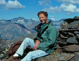
Joe L’Orsa – Harry Kruisselbrink photo

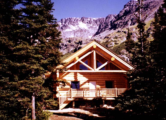
Joe L’Orsa was one of the first people who befriended Lynn and subsequently me when we moved here. He lived with his family in the house his parents built on the Telkwa-Moricetown Highroad in the 1940s; his mother Harriet lived in a smaller house she had had built nearby in the late sixties. I still have mint from her garden – a hardy variety that finds itself a place among the vegetables every year.

Since Harriet died at age 90 in 1987, her house has been rented out to a variety of people – single men and women, couples, young families – many of whom had strange encounters there. But even while Harriet was alive, there was an unsettling sense about the place.

Sherry Wertz remembers that Harriet lived on her own, managing all the tasks of daily living. “She was somewhere in her eighties at the time and she was able to take care of herself and so on, but she would often talk to people we couldn’t see. Maybe her sister or others. She’d scold people who didn’t use the doors like other people did to come inside the house. We’d just go along with her and say hello to her friends. Aside from that, she was fine.”

Sita Then, who lived there after Harriet died, wrote:

Joe told me that his farm was on “a thin spot”, a magnetic line, a place where our plane of existence and another could be crossed.  He explained to me that his mother was always surrounded by people from this other plane and that she treated them as if they were real. The Earth had a grid of magnetic lines, he said, and Smithers, his home and the Babine Mountains were all directly on this one.

The magnetic grid theory was one Joe shared with many people. But the stories around Harriet’s house are more specific. Some tenants found that objects seem to get moved around; the teapot left on the table would be found in another room; a doll would appear that didn’t belong to any of the children in the house. Others talked about hearing children playing outside. One fellow who pooh-poohed the stories, reportedly left after spending a single night there. Another visitor, his sister reported, woke up “absolutely terrified.

Joe’s brother Tony, who lived in the house with his mother for a time, dismisses the stories. I’m ambivalent. I haven’t experienced anything to make me believe in ghosts or thin spaces between planes of existence, but people I respect seem to have a sense for such things. And when I asked for stories about Harriet’s house, I got a bit of a surprise. Both Sherry and Sita have never spoken to each other about what they experienced, but their stories bear a remarkable resemblance. And each one had a witness.

Here’s what Sherry said happened when she and her daughter spent a night with Harriet:

It was somewhere in December – it was cold and wintery and there was snow on the ground. Megan and I went to bed in the spare bedroom.  Somewhere between two and three a.m., I heard a lot of noise, men talking, and some banging around. I got up and went to Harriet’s room because she did sleepwalk sometimes and I was worried she might have gone outside in the cold. But she was there, asleep in her room.

It was quite loud and seemed like it was just outside the kitchen window. It sounded like someone was loading heavy metal objects or something. I turned on the outside lights, but there was no one there. The noise had also awakened Megan – in her toddler way she asked me what the noise was and was someone here?

Here’s what Sita wrote:

It was winter, and the snowy afternoon had continued into the evening, but by bed time the sky had cleared, the snow had stopped, and the temperature had fallen considerably.  The brightness of the moon on the L’Orsa fields shone through the generous windows of Harriet’s old house illuminating our squat furniture and casting deep shadows all around.  Sound tends to travel well on nights like that, as we noticed when both Ron and I woke to noises both loud and close.  Even with the atmospheric mood taken into account, the sounds were simply too close and too loud to be anywhere but in the parking area around the back of our house.  Without even discussing it, we both launched out of bed to see what the heck.

Straight to the back door we went, both of us stopping with our noses up to the glass, searching the crystal blue night for what sounded like two men talking to each other and unloading empty metal milk containers like the old fashioned ones from a dairy.  We were sure that it was the sound of these empty containers rolling across a truck’s flat deck and then onto the ground. But not how it would have sounded if they fell on snowy ground. And outside our door there was at least a foot of brand new sparkling snow.

But now we heard nothing, just our own breathing as we stood peering out through the glass.

Still without a word we bolted back to the living room to look out those windows to help us make sense of the noises we had heard. Seeing no trace of truck or men, we looked for tire tracks or human tracks. But all the moon showed us was the flawless skin of untracked snow.  No deep blue shadows of tire marks, no clumsy human footprints to break up the perfection that was the landscape of that night.

Uneasy, we vowed that in the morning, we would go over to Joe’s to see if he’d heard anything or was up to some late night milk container rolling.  In the morning, we skipped coffee and put on our gear to see what we could see. We found exactly what we had seen from the windows the night before, a landscape of perfect, untrammelled snow.

We shovelled out the truck and returned to our warm kitchen for breakfast.  I called Joe’s house.  I asked him if he’d heard what we had, or if he’d had some nocturnal projects on the go. He hadn’t.  So we were left with a few options: was it uncommonly audible sound traveling from far away, had we both dreamt the same dream and awakened at the same time, or was it the past speaking to us?

It would have been easy for us to go over to the Nageli’s dairy farm further down the road and ask them what sort of mischief they were up to the night before. Maybe we would have found our answer there. But maybe we wanted the mystery of “the thin spot”.  Maybe we wanted to affirm the crowd of spirit visitors that kept Harriet company every day of her life in the Bulkley Valley. Maybe we wanted to be part of the great unknown of magnetic lines connecting the places we loved.  Maybe we too had crossed over to another plane and startled some other people awake with our industry and chatter. After all, who doesn’t want to be a ghost?

Neither woman felt threatened by the sound. “It wasn’t scary,” Sherry said. “It was just as if I had tapped into someone else’s life. Later I thought about Harriet’s visitors and I thought it could be an overlap of some kind – some dimensional thing.”

Over the years a couple of cleansing ceremonies were done and reports indicate there haven’t been any incidents for many years. Or at least none people are talking about. But rumour has it there may be spirits hanging around Glenwood Hall and Driftwood Schoolhouse…just think of all those weddings and funerals…


Harvey Mountain Trail – making connections

Sunday, Sept. 3, 2017

It’s impossible to stay indoors when the weather is like this – warm, bug-free and with the added pressure that you know it can’t last. So Lynn and I head up Harvey Mountain Trail to walk one of my favourite Babine Mountains loops. As we begin our climb, I think about how these trails start off steep, with no gentle warm up. For a few minutes the loudest sound is my heart pounding as it overcomes its initial surprise that I’m making such inconsiderate demands. Soon things settle down and I hear a creek on my right. It fades in and out of earshot as the trail switches back and forth and you never see it unless you go looking for it further up. I don’t know of any name for it, unless it’s the Harvey Creek Joe L’Orsa refers to in his history of the Babines.

The air has the heavy smell of September – vegetation turning into next spring’s compost. Brilliant clusters of bunchberry. The columbine gone to seed, scraggly daisies in the gravel.

We hear a woodpecker enjoying a Sunday brunch, golden-crowned kinglets at one sunny turn, a hawk screeches once, twice, and then falls silent. Lynn scares a ruffed grouse and her chicks out of the thimbleberries. We come to the first viewpoint and look back down the canyon toward a valley choked with fog. The morning flight from Vancouver circles, looking for an opening.

The packrat hotel

Rounding the corner of the next switchback, I catch of whiff of packrat. Always right here, at a rocky outcrop. And as you walk through the smell and beyond it along a straight, relatively level stretch of relief for your heart, you come to the remnants of Peavine Harvey’s cabin. When we first hiked this trail, you could step inside the cabin – now there’s a jumble of tumbled down boards, a few metal scraps, and fireweed poking through the debris.

The remnants of the cabin

This is where you can finally see the creek, but you have to go look for it. If you don’t make the switchback turn you’ll see a small trail leading over to what there is left of it this time of year.

Dry rock where the trail crosses it at the base of a steep cliff. Up above, the creek is a trickle, a little riff and gurgle before it disappears again. If you keep going along the base of the cliff, you’ll come across old evidence of the work Peavine put in over the years, but the main adit is a pile of rocks.

According to Joe’s history of the Babines, Peavine Harvey was already digging into the flank of this mountain as early as 1905. “The Pack Train claims were owned by C.G. ‘Peavine’ Harvey, Chas. (‘Charlie’) Barrett [Barrett Hat, Barrett Station all named in association with nearbyBarrett Lake, in turn named after Charles Barrett, early settler and c1900 owner of the Diamond D Ranch], and Jno. Charleston, and were what later became known as ‘The Harvey Mine’.” By 1909, he had excavated “41 feet of tunnel, four open cuts and a shaft 35’ deep.”

In 1914, Peavine moved his family to the land either Eli Fletcher or Peavine himself originally pre-empted. Joe writes, “Between 1915 and 1918, C. G. Harvey shipped approximately 25 tons of ore.” In 1919, a “new trail to the Harvey property, from the wagon road up Driftwood Creek, was constructed….On the Harvey Group, at that time owned by C. G. Harvey and W. J. Larkworthy, considerable work was done, including a shaft sunk to a depth of 40’.”

In the early days, I suspect it was pretty much all men and pack horses coming up this way. And the “new trail” Joe writes about was likely built with crosscut saws, pickaxes and shovels – it’s hard to imagine. Shipping ore? Pack horses or wagons? I remember Ralph Dieter telling us how he’d run/walk to town and back for the mail. It was really faster than horses, he said. Later mechanized activity turned this into a road and as you’re hiking towards the top, it goes straight up into the alpine where remnant tracks are still visible. I suspect these last tracks come from activity Joe reported for 1971-72. “Driftwood Mines cut a grid and did other work on Harvey Mountain. The project was then abandoned.” Peavine had died in 1945 and I never heard word that Gordon did any mining.

Before logging began in the 1950s (see Driftwood Creek Bush Mills), the trail was not the industrial corridor I thought it must have been from the amount of prospecting that was going on. Joe’s history refers to a letter his mother, Harriet, wrote after her return to the family home in 1964:

“Take for instance the Driftwood Creek road above Harveys’. Twenty-five years ago, this was probably the most beautiful forest road in the Valley, winding along the edge of Driftwood Creek and bordered by towering evergreens. “Sunny Point” was a tiny Paradise and a stopping place for many.”

Once on top of Harvey Mountain, the history all falls into place. Looking back and down, I can see, visible above the morning fog, the big hayfield just above our house, a hayfield that Eli Fletcher was cutting over one hundred years ago. I can see the route Gordon, Peavine and Katherine followed with Billy Kirtin into the canyon.* I can trace the creek all the way to its headwaters above the Joe L’Orsa cabin in Silverking Basin.

I can also see signs of activities that precede any of the settler community.  The rugged outcrops, dizzying goat descents, their dustbaths, their scat and a few scraps of goat hair caught in the vegetation. The crackling of the lichen the caribou preferred when they lived in these mountains. The horned larks flocking up before they leave.

We wander across, eat lunch looking down on Number Six Lake, and nap in the sunshine before we start the descent.

A creek trickles and bubbles down through scenic grottoes, the crackling lichens from up top giving way to mauve gentians, stalks of fireweed gone to seed, ratty little fleabanes, shabby monkshood. Brilliant hellebore. As we follow the creek we leave, for an hour, the Driftwood watershed. This creek drains into Lyon Creek, Ganokwa Creek, Canyon Creek. We circle around the mountain, see the town is now as clear and sunny as we’ve been all day. We walk down, back once again to Driftwood Creek. We’ve been out for six or seven hours and haven’t seen another person all day. Heaven.

*The Harveys show up many times in this blog: check out Gordon Harvey – tenacity and transience.

Silverking Basin

by Harry Kruisselbrink

Harry has lived in Smithers since soon after his family arrived in the Bulkley Valley in early 1951. He served on town council for many years and was a dedicated environmental activist and researcher. He is a wonderful photographer (the photos here are from his collection) and has helped record local history, working with Lynn Shervill on Smithers: From Swamp to Village and writing his own Smithers: A Railroad Town. He is also a great friend. Like many of us, he can’t help returning, year after year, to the beautiful Silverking Basin where Driftwood Creek begins its journey to the Pacific.


Harry and Juanita

By the late 1960s, Audrey and I had been to Silverking Basin quite a few times before we had the kids. Once we had them, it became a little harder. Leroy was born in 1966 and Juanita in 1969 (Charmaine was still four years down the road). It then occurred to us that we could actually take the kids into the basin and stay for more than just the day. The first time we did that was in July 1970. Leroy was a three-year-old getting close to four. Juanita was a year-and-a-half old.

When my fellow CN employ Robbie Robinson found out what we were thinking, he volunteered to drive us into the basin with his 4-wheel drive. He also offered to pick us up later on in the week. Well, that was an offer we obviously could not refuse! So on a nice summer Monday morning, Robbie drove us into the basin. In those days driving a vehicle into the basin was allowed since the Babines were not even a Recreation Area. The road was muddy and bouncy but we made it into the basin in one piece.  Robbie said he’d pick us up again sometime on Friday. And so we moved into the cookhouse that was still habitable in those days. The cabin was built in the 1920s and was formally named the LaMarr cabin – after the beautiful and famous movie star Hedy LaMarr of the early 1900s.

Audrey, Leroy and Juanita at the cookhouse. 1971.


It turned out to be a beautiful week although that is not a word that we could use to describe ourselves. We agreed that Audrey wouldn’t fuss with her hair and I wouldn’t shave. All of us wore old clothes. So you can imagine that we were a rather forlorn looking bunch by the end of the week.

Everything worked out very well although Audrey was not happy about the mice that roamed through the cookhouse at will especially at night. The floor was of two-inch lumber and, over the years, the knots had dropped out of the knotholes and they had become just plain holes allowing easy access for the mice. The kids slept on the bunk at the back of the cookhouse but Audrey and I had to sleep on the floor. This meant that at night we could feel and hear the nice running over our sleeping bags. Not a situation to Audrey’s liking.


Lynn Shervill in Silverking – the bunkhouse and the foreman’s cabin. 1978.

We had considered moving into the big bunkhouse next door but seeing all of the mouse droppings on the floor and the even easier access the mice had there, we dropped that idea. For me, it wasn’t so bad. My family lived for sometime in a decrepit old log house in Barrett Lake, a haven for mice, and we discovered there that mice will run over you at the slightest opportunity but they will not touch the face of a living human being. I told Audrey this but she was not convinced nor impressed! The solution to the problem lay in the old garbage dump in the bush just behind the cookhouse. There were dozens of old rusty tin cans laying around with lids just the right size to cover the knotholes. In the bunkhouse, we found a pair of pliers, some rusty nails and a hammer. By the end of the second day, we had closed all of the knotholes and were now looking forward to a good night’s rest. We had just barely gone to sleep when we were awakened by the sound of “thumps in the night”. You could hear, quite loudly, metallic sounding thumps. Thump, a bit of silence and then thump again. Then the process repeated itself several times. Soon we were hearing thumps in three or four places on the cabin floor. It didn’t take us long to discover the source of the thumps. It was the mice trying to come up through the knotholes. You could practically hear them thinking, “I can’t figure this out, I’ve been coming through this knothole for years! What is happening here? Let me try it again!”  Thump…..! It was really quite funny but also very effective in keeping the mice out – and Audrey was happy.


Fortunat L’Orsa 1906 – 1953

We had a truly wonderful time. We hiked over Hyland Pass into Hyland Basin, we paid a visit to Fortunat L’Orsa’s grave and planted some flowers around it, we checked out the old mining adits, etc. The weather was great all week and we got totally relaxed though rather scruffy looking. So relaxed, in fact, that one day, while I was taking a picture of my crew, little Leroy suddenly blurted out, “Dad, there’s a man….!” In those days hardly anyone came into the basin so our intruder caught us completely off guard. It turned out to be Forbes Lee who was the Secretary-Treasurer of School District 54. We had not met before but as a result of that meeting we became good friends. Forbes explained that he tried to be as obtrusive as possible so as not to scare us but Leroy caught him in the act! He was the only person we saw for the entire five days!

True to his word, Robbie picked us up on Friday afternoon and drove us back home. When we arrived in town, it seemed to us that everyone was running around in such a hurry. We had become so relaxed that even the citizens of laid-back Smithers seemed to be in a perpetual hurry!

The following year, Joe L’Orsa drove us into Silverking again for, by now, we were totally hooked on the basin. We’ve been coming back there many, many times over the years always spending five days there. Even our grandchildren are now hooked on this beautiful basin. It has added a very meaningful dimension to our lives.

Lynn and Sheila at the Joe L’Orsa cabin with Harry. 2015.

Harry Kruisselbrink and Joe L’Orsa (more on him later) were two of the most important people in our introduction to the community and the Babine Mountains. Harry likes to tell of story of how he and Joe decided to befriend Lynn when he first arrived to work at the Interior News in 1976 because he wore hiking boots. Soon after, they took him into the mountains. And Lynn took me …

McCabe Trail

Three routes from Driftwood Road give access to Harvey Mountain: Lyons Creek, Harvey Mountain and the McCabe trails.

I first set foot on the McCabe trail in 1977 or 1978, can’t quite remember which. Joe L’Orsa took a group of us (including Walt Taylor, Mike Morrell and his son Tomas) up the Lyons Creek trail to the lake just above its headwaters where some of us swam. We then dropped down on what is now called the Blix trail until a tiny path emerged out of a wet meadow full of flowers. Mike and his son went right to follow the McCabe trail to its summit above the Little Joe lakes; the rest of us turned left to follow the trail down to Sunny Point.

This was not yet a park and there were no signs signaling trail heads or route distances. But we had Joe who grew up travelling in these mountains with his family. At the hike’s beginning, he stopped just below the Lyons Creek trail entrance to show us where the trail originally began. It used to be called the Gale & Lifton trail and was, he wrote in his unpublished A History of the Babine Mountains Recreation Area, “already considered an old trail by 1921. It may have followed an ancient Indian entry route, possibly into the marmot ground near Ganokwa Basin.”

We passed the old sawmill site, the remnants of which are still visible, and struggled up the hill to the long central stretch where the climb abates for a few kilometres. The trail was often muddy and not always clear. Joe was very patient as we struggled towards treeline. Hiking was still new to me and I suffered from the delusion that if you sweated and struggled up steep inclines swatting mosquitoes, you weren’t having fun.

Once in the alpine, we followed the trail around to its junction with the route leading over Padella Pass and turned left to follow the creek up to the lake we call Number Six Lake (if you look down from Harvey Mountain you can see a six or a nine clearly drawn by the lighter sediments on the lake bottom). The shintangle almost obliterated the trail up the creek, and the route down was equally sketchy. It was hard at the time to believe Joe’s stories of taking horses down there. It’s still hard.

Once on the McCabe trail, we had a pleasant walk out though I don’t remember much of that specific trip. When I think about how many times we’ve walked it since, the years blur together. We often take visitors up to a lookout point where you can see across into Silverking and catch a glimpse of the cabin there. The dramatic drop is stunning and we almost always see goats.

According to Joe’s research, the trail was built in 1919:

The famous McCabe trail was constructed, from the wagon road below Sunny Point, along the backside of Harvey Mountain, to the Copper Lakes area. This trail was built – or caused to be built – by Red McCabe, on a trail grant under the provision of the Mines Development Act.

Red McCabe didn’t get his name from the colour of his hair: he was the president of the local chapter of the old Socialist Party of Canada and prospected with two other party members – Pat McPhee and Jim Carson.

McPhee had been prospecting in the area for at least fifteen years by then. Joe describes a trip taken in 1905:

Provincial Mineralogist W. F. Robertson makes a major trip from Quesnel to Hazelton. From a camp at the Hudson Bay Ranch in Driftwood, he visits the Babine Range, with Pat McPhee as a guide. Apparently they went up what is now the Lyons Creek Trail and visited the … claims on what is now known as Harvey Mountain.

Jim Carson had a camp just above the bridged creek that crosses the trail below its opening into the boggy meadows where the Blix trail takes off.  Joe showed us the remnants of his camp as we walked out. The only evidence now is a wire scar left in a big spruce tree where he pitched his tent. (Carson Basin, a long gentle slope on the north flank of Pyramid Mountain, is also named for him. If you poke around up there, you’ll find lots of old adits.) I’ve been told Axel Elmsted, another longtime Babine Mountains prospector,  used to call the mountain Bolshevik Hill because of the three men’s political affiliations.

After crossing several brushy slide areas, the trail further down traverses a big rock slide that pre-dates its original construction. If you stand on it and look down, you’ll see just below another path crosses the rock – this is the trail that leads down to the spot on Driftwood Creek where the engineers who surveyed the trail (hence it’s pleasant grade) camped. More on that another day.

Tony L’Orsa, Joe’s older brother, still remembers when the McCabe trail was wide enough to be the wagon road instead of the narrow path it is today. There used to be a cabin not far from Sunny Point which was burned down by the forest service, he said. Later exploration tore up the original trail’s beginnings, but it remains one of the most scenic routes into the Babines and, on its lower reaches, provides splendid views across the upper Driftwood watershed.

Into Silverking

After reading Mel and Evi’s memories of Gisela and Silverking, we set off on Sunday to see just how far we could get into the basin before the snow defeated us. Last year this time, remnant snow appeared just after the Danny Moore confluence and we were only able to get as far as the cabin because a handy troupe of high school students had snowshoed in a few days earlier and a hard frost the night before solidified their track very nicely for us.

This past Sunday, we once again had a nasty frost down in the canyon; luckily I responded to the cold and clear sky just before I went to bed and covered the marigolds and zucchini. Ice furred the perennials and froze any standing water. Most plants survived, though I’m sure they’re all just a little shocked. But I checked back in our weather diaries – about 20 years worth – and June frosts appear regularly. As do days with highs of 30.

Elderberry bursting into leaf.


We had easy walking most of the way. Saw a harlequin pair just below Danny Moore creek, rays of light illuminating the male’s colours. A spruce grouse in a sub-alpine fir  – red eyebrows flashing in the gloom. The greenery exploding; yellow violets, some budding lupines.

If you look closely, you can see the harlequin pair.

Then, just below the basin, snow. And postholing. It’s like walking a tightrope strung about three feet above the ground … stepping lightly, balancing, holding your breath, arms out until wham, you break through, thigh deep in snow. Haul your leg out and recommence the breath, the light steps until you’re down again. You look ahead at your companions who stagger like drunks, lurching and cursing.


But it was well worth it, eating lunch on the deck of the Joe L’Orsa cabin, sun shining, no mosquitoes. I notice in our weather diaries this time of year, all the notes about bugs or the blessed lack of them. We were lucky.


The cabin is beautiful – a log structure that is much more than a cabin. Built by local log house builders, Wes Giesbrecht and Dennis Clark, I well remember the day they helicoptered the huge logs from Wes and Dennis’ building site right over our house into the basin. More on that another day.


There are three log books in the cabin now – all telling stories of visits to the basin, summer, fall, winter and spring. School trips, visitors from around the world, people re-visiting their youth, remembering loved ones, out for adventure. The ones who come year after year. Notations about birds, plants, snow depth, avalanche risk, the state of the cabin, animal sightings.


Just as we walk the same stretch of road day after day, year after year, noting both returns and losses, seeing how the freshet changes the curve of the creek, tumbles old trails into the water, we walk year after year into Silverking Basin. Remembering when the big flood took out the bridges. When the road was re-routed and new creekbeds carved. Grateful to still be able to make the journey.

Lynn inside Joe L’Orsa cabin.


Silver King Basin

lynn-going-into-silverking-1976-001Cleaning out some old files at the turn of the year, I came across this old photo of Lynn Shervill packing a new airtight wood burner into what was called the foreman’s cabin in Silver King Basin in the fall of 1976. The photo was taken by Steve Whipp, the reporter I replaced when I moved to Smithers in January 1977.

I think the log bridge crosses Driftwood Creek at Sunny Point – in the background it looks like the road descending from left to right.


It was just a few months later in January 1977 that Lynn took me into the basin, a ten-mile ski that started out gently but climbed steeply for the last stretch before we emerged into the basin itself. I hadn’t skied more than once or twice before we went. I borrowed long skinny skis and an oversize backpack from Steve and set out, convinced I could do anything. I don’t remember much about the trip in except feeling pretty good about things by the time we reached Sunny Point, the easy first half. Suffice it to say that we finally got to the foreman’s cabin a couple of hours later than Lynn anticipated. I was exhausted.


lynn-on-the-trail-338x600


The trail we followed up Driftwood Creek was one of three main prospecting routes into the Babines, as far back as the late 1800s. By 1905 several claims had been staked in the Driftwood drainage, including those of C.G. ‘Peavine’ Harvey after whom Harvey Mountain is named. In 1914 Peavine, his wife Kathleen20170204_114616_hdr_resized and infant son Gordon moved to their homestead on Driftwood Creek just up the road from our house. One of our snowshoe trails follows that old road, still visible as it leaves the hay fields and descends down to the creek near the old Harvey homestead.

20170204_114351_hdr2_resized

One of Gordon’s rakes, abandoned on our neighbour’s property in what was Gordon’s hay field.


While the Driftwood route into Silver King is a popular skiing and hiking trail into what is now the Babine Mountains Provincial Park, it was probably even busier in the 1920s. As Joe L’Orsa wrote in his unpublished history of the Babines, “In the words of Axel Elmsted, who was one of them, ‘The hills swarmed with old fossils.’ The Oldtimers, short on both modern-day geological techniques and clairvoyance but long on energy and elbow grease, dug innumerable trenches, tunnels, shafts, and pits, often on a little quartz stringer or bit of copper stain.”

The Lyon Creek Trail was once called the Gale & Lifton Trail and is thought to follow an old Wet’suwet’en route to hunt marmots in Ganowka Basin. A new trail was built to the Harvey mineral claim from the wagon road up Driftwood Creek, now known to hikers as Harvey Mountain Road.The McCabe Trail was built from the wagon road below Sunny Point along the back side of Harvey Mountain by Red McCabe on a trail grant under the provisions of the Mines Development Act.

The claims in Silver King Basin were among the earliest staked. According to L’Orsa,  a working adit was driven in at 4960’ in for 252’ where it “hit promising mineralization.” From the basin, the wagon road followed what is now a footpath zigzagging up the northeast wall over Hyland Pass to the Cronin mine. Exploration activity continued in the basin into the 1980s, hence the foreman’s cabin.

foremans-cabin-600x597

This is what the foreman’s cabin looked like in the summer of 1980. Sam?, Sheila and Daniel on his first trip to the basin.

By 1977, the foreman’s cabin was the most weather-resistant shelter left; there was an old cookhouse and a bunkhouse – the cookhouse by this time was full of packrat stink and porcupine quills and the bunkhouse was so big and drafty it was impossible to heat in winter. It was cold that night and my new sleeping bag wasn’t all it was cracked up to be.

In the morning, we explored the basin on skis – how nice was that without an oversize pack? – and then headed back down the trail. Anyone who has skied the trail knows about all the little divots along the way – seepages that melt the snow and form dips in the trail that are exciting for some, but were disastrous for me. I spent quite a bit of time either face down in the snow with the pack shoving me deeper in or face up like a beetle on its back, legs scrambling for purchase. The snow was deep. It was hard to get up. By the time we reached Sunny Point and the gentler sections, I was ready for a gentle cruise back to the car. No such luck. The trapper’s snowmobile had turned the track into an icy moguled death run for the unskilled. I seem to recall finally removing my skis and walking.

What’s truly a surprise after that inauspicious introduction to back country skiing is that I eventually married the fellow who took me in there. He was such a natural athlete he never thought to show me any technique to slow down or make even the gentlest turns. The only way I really knew how to stop on skates was to run into the boards; the only sure way I could stop on skis was to fall. And perhaps that’s why, now, my preferred winter footwear are snowshoes.

panorama-2-600x124

Silver King Basin holds the headwaters, the beginnings, of Driftwood Creek. It also feels like the place where my life in this part of the world began. Where the stream that carried me from the coast east to Ontario and finally to the northwest set a new course, creating for me a confluence with Driftwood Creek, with Watsonquah (the Bulkley), with the Skeena.  With home. So maybe it isn’t such a surprise I married Lynn. He was the first to take me into the mountains, into those mountains. I’ve never lost that feeling, felt for the first time on that trip into Silver King. A love for high places, for their loneliness and often desolation. For the way they remind you just how precarious and precious our tenure is. Here’s what I wrote the evening I got home:

sheila-in-cabin

Sheila in the foreman’s cabin, July 1977

It was worth it, as are most efforts which result in a high clear place where the wind blows from the top of the world and carries nothing but the air with it. It is eerie and lonely, almost frightening as I remember it from this warm house with the radio chirping away and my impatiens plant blooming. Skiing down into a vast white bowl, over marshes, creeks, boulders and a million varieties of mosses. Sinking not at all into the smooth white crust which covers the entire basin. The cabin was cozy with orange firelight flickering over golden walls of unfinished wood. But I couldn’t sleep – a funny scary feeling about all the things that could go wrong.

We have been back to Silver King Basin many times, though the foreman’s cabin is long gone. Over the years hundreds of visitors inscribed their names on the walls of the old buildings and wrote notes in the log book each new place holds. An elegant log building now provides luxurious shelter for folks who make their way in there, as they do in all seasons. And the basin is even more beautiful now as more and more of the old mining debris has been removed.

silverking-from-dc-headwaters-1977

The headwaters of Driftwood Creek above the mining buildings in 1977.

lynn-in-silverking-1977

Lynn looking across toward Mount Hyland from Silver King Lake.

sheila-at-silverking-lake

Sheila at the outlet of Silver King Lake, July 1977.